
Պատկեր:Un-nepal.png

Սկզբնական նիշք (3038 × 2257 կէտիկներ, նիշքի չափը՝ 1,56 ՄԲ, MIME-տեսակը՝ image/png)
Ամփոփում
| Նկարագրութիւն |
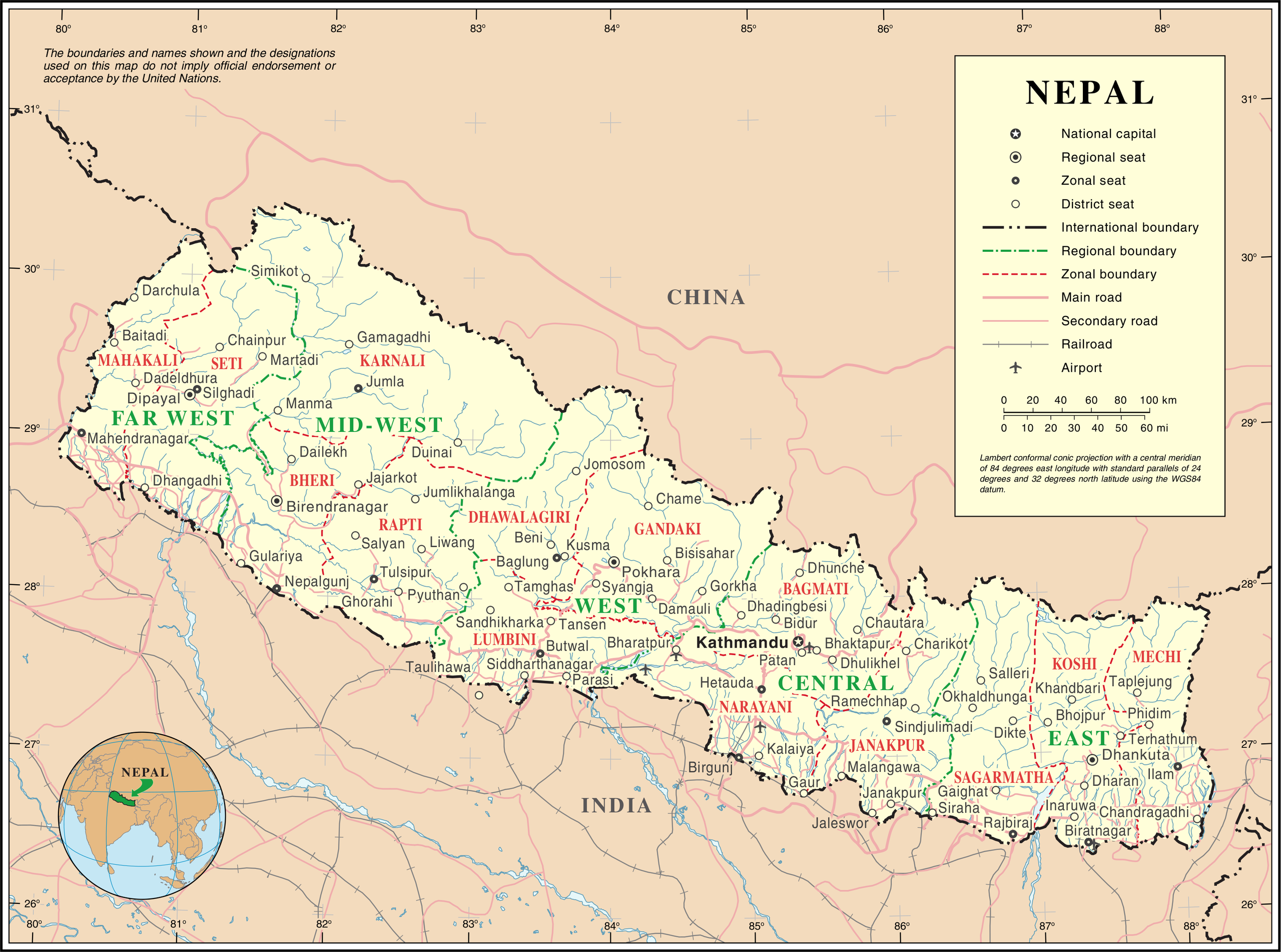
English: Map of Nepal highlighting development regions (green) and administrative zones (red), both disestablished in 2015 |
|||
| Թուական | before 25 Հոկտեմբեր 2007 | |||
| Աղբիւր | United Nations | |||
| Հեղինակ | անհայտ | |||
| Արտօնութիւն (Նիշքի վերօգտագործում) |
|

Նիշքի պատմութիւն
Սեղմել օրուան/ժամին վրայ նիշքի այդ պահուն ունեցած վիճակը տեսնելու համար
| Օր/Ժամ | Մանրապատկեր | Ծաւալ | Գործածող | Մեկնաբանութիւն | |
|---|---|---|---|---|---|
| ընթացիկ | 01:36, 24 Հոկտեմբեր 2007 | | 3038 × 2257 (1,56 ՄԲ) | Jeroen | {{UN map}} Category:Maps of Nepal |
Նիշքի գործածութիւն
Հետեւեալ էջը կը յղուի այս նիշքին՝
Նիշքի համընդհանուր օգտագործում
Հետեւեալ ուիքիները եւս կ'օգտագործեն այս նիշքը՝
- Օգտագործումը af.wikipedia.org կայքին վրայ
- Օգտագործումը az.wikipedia.org կայքին վրայ
- Օգտագործումը ba.wikipedia.org կայքին վրայ
- Օգտագործումը bh.wikipedia.org կայքին վրայ
- Օգտագործումը ca.wikipedia.org կայքին վրայ
- Օգտագործումը de.wikipedia.org կայքին վրայ
- Օգտագործումը en.wikipedia.org կայքին վրայ
- Օգտագործումը fi.wikipedia.org կայքին վրայ
- Օգտագործումը fr.wikipedia.org կայքին վրայ
- Օգտագործումը ja.wikipedia.org կայքին վրայ
- Օգտագործումը krc.wikipedia.org կայքին վրայ
- Օգտագործումը nl.wikipedia.org կայքին վրայ
- Օգտագործումը pap.wikipedia.org կայքին վրայ
- Օգտագործումը pcd.wikipedia.org կայքին վրայ
- Օգտագործումը pl.wiktionary.org կայքին վրայ
- Օգտագործումը roa-rup.wikipedia.org կայքին վրայ
- Օգտագործումը ru.wikipedia.org կայքին վրայ
- Օգտագործումը sco.wikipedia.org կայքին վրայ
- Օգտագործումը sl.wikipedia.org կայքին վրայ
- Օգտագործումը ta.wikipedia.org կայքին վրայ
- Օգտագործումը th.wikipedia.org կայքին վրայ
- Օգտագործումը tr.wikipedia.org կայքին վրայ
- Օգտագործումը uk.wikipedia.org կայքին վրայ
- Օգտագործումը ur.wikipedia.org կայքին վրայ
- Օգտագործումը www.wikidata.org կայքին վրայ
- Օգտագործումը xmf.wikipedia.org կայքին վրայ