
Պատկեր:Public transport map of Rio de Janeiro.png

Կանխաստուգման չափը՝ 800 × 547 կէտիկ։ Այլ չափեր: 320 × 219 կէտիկ | 640 × 437 կէտիկ | 1024 × 700 կէտիկ | 1280 × 874 կէտիկ | 2560 × 1749 կէտիկ | 8777 × 5996 կէտիկ.
Սկզբնական նիշք (8777 × 5996 կէտիկներ, նիշքի չափը՝ 15,03 ՄԲ, MIME-տեսակը՝ image/png)

|
This transport map image could be re-created using vector graphics as an SVG file. This has several advantages; see Commons:Media for cleanup for more information. If an SVG form of this image is available, please upload it and afterwards replace this template with
{{vector version available|new image name}}.
It is recommended to name the SVG file “Public transport map of Rio de Janeiro.svg”—then the template Vector version available (or Vva) does not need the new image name parameter. |
Ամփոփում
| Description |
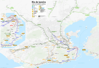
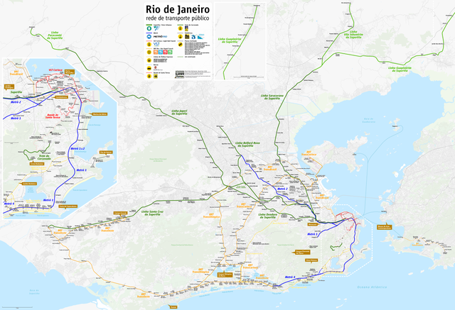
Deutsch: Karte ÖPNV Rio de Janeiro
English: Public transport map of Rio de Janeiro
Français : Plan des Transports publics de Rio de Janeiro
Português: Mapa do transporte publico do Rio de Janeiro
Need Assistance! I don't live in Brazil, but I want to make the map as accurate as possible. Informations given in medias and the Web about public transport systems are often incorrect or very inaccurate. So if you want the network map as accurate as possible too, please announce your error hints and corrections about the correct network configuration on my German discussion page. Thank you in advance! |
|||
| Թուական | see file history | |||
| Աղբիւր | Սեփական աշխատանք, using OpenStreetMap data for the background | |||
| Ստեղծել է | ||||
| Արտօնութիւն (Նիշքի վերօգտագործում) |
All OpenStreetMap data and maps are Creative Commons "CC-BY-SA 2.0" licensed This file is licensed under the Creative Commons Attribution-Share Alike 2.0 Generic license.
|
|||
| Georeferencing | If inappropriate please set warp_status = skip to hide. | |||
| Այլ մեկնակերպներ |
|


Նիշքի պատմութիւն
Սեղմել օրուան/ժամին վրայ նիշքի այդ պահուն ունեցած վիճակը տեսնելու համար
| Օր/Ժամ | Մանրապատկեր | Ծաւալ | Գործածող | Մեկնաբանութիւն | |
|---|---|---|---|---|---|
| ընթացիկ | 21:13, 23 Նոյեմբեր 2018 | | 8777 × 5996 (15,03 ՄԲ) | Chumwa | update, more info |
| 06:08, 24 Յունուար 2018 |  | 8777 × 5996 (15,03 ՄԲ) | Chumwa | ||
| 19:11, 12 Յունուար 2017 |  | 8777 × 5996 (15,03 ՄԲ) | Chumwa | ||
| 04:29, 13 Սեպտեմբեր 2016 |  | 8777 × 5996 (15,02 ՄԲ) | Chumwa | ||
| 18:28, 5 Օգոստոս 2016 |  | 8777 × 5996 (15,02 ՄԲ) | Chumwa | ||
| 07:46, 17 Յուլիս 2016 |  | 8777 × 5996 (15,04 ՄԲ) | Chumwa | ||
| 18:52, 2 Յուլիս 2016 |  | 8777 × 5996 (14,98 ՄԲ) | Chumwa | ||
| 20:41, 26 Յունիս 2016 |  | 8777 × 5996 (14,98 ՄԲ) | Chumwa | ||
| 20:25, 20 Յունիս 2016 |  | 7201 × 5996 (12,34 ՄԲ) | Chumwa | ||
| 20:42, 19 Յունիս 2016 |  | 7201 × 5996 (12,34 ՄԲ) | Chumwa |
Նիշքի գործածութիւն
Հետեւեալ էջը կը յղուի այս նիշքին՝
Նիշքի համընդհանուր օգտագործում
Հետեւեալ ուիքիները եւս կ'օգտագործեն այս նիշքը՝
- Օգտագործումը ar.wikipedia.org կայքին վրայ
- Օգտագործումը ba.wikipedia.org կայքին վրայ
- Օգտագործումը be-tarask.wikipedia.org կայքին վրայ
- Օգտագործումը bg.wikipedia.org կայքին վրայ
- Օգտագործումը bn.wikipedia.org կայքին վրայ
- Օգտագործումը bs.wikipedia.org կայքին վրայ
- Օգտագործումը da.wikipedia.org կայքին վրայ
- Օգտագործումը de.wikipedia.org կայքին վրայ
- Օգտագործումը en.wikipedia.org կայքին վրայ
- Օգտագործումը en.wikivoyage.org կայքին վրայ
- Օգտագործումը eo.wikipedia.org կայքին վրայ
- Օգտագործումը es.wikipedia.org կայքին վրայ
- Օգտագործումը es.wikivoyage.org կայքին վրայ
- Օգտագործումը eu.wikipedia.org կայքին վրայ
- Օգտագործումը fa.wikipedia.org կայքին վրայ
- Օգտագործումը fi.wikipedia.org կայքին վրայ
- Օգտագործումը fr.wikipedia.org կայքին վրայ
- Օգտագործումը fr.wikivoyage.org կայքին վրայ
- Օգտագործումը he.wikipedia.org կայքին վրայ
- Օգտագործումը he.wikivoyage.org կայքին վրայ
- Օգտագործումը hu.wikipedia.org կայքին վրայ
- Օգտագործումը hy.wikipedia.org կայքին վրայ
- Օգտագործումը id.wikipedia.org կայքին վրայ
- Օգտագործումը it.wikipedia.org կայքին վրայ
- Օգտագործումը it.wikivoyage.org կայքին վրայ
- Օգտագործումը ja.wikipedia.org կայքին վրայ
- Օգտագործումը ka.wikipedia.org կայքին վրայ
- Օգտագործումը nl.wikipedia.org կայքին վրայ
- Օգտագործումը nn.wikipedia.org կայքին վրայ
- Օգտագործումը no.wikipedia.org կայքին վրայ
Տեսնել այս նիշքի աւելի համընդհանուր օգտագործումը: