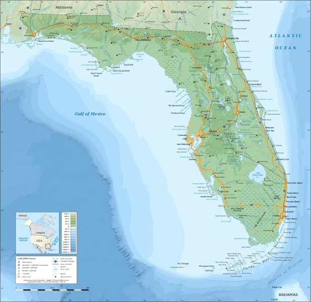
Պատկեր:Florida topographic map-en.svg
Արտաքին տեսք

Size of this PNG preview of this SVG file: 617 × 600 կէտիկ. Այլ չափեր: 247 × 240 կէտիկ | 494 × 480 կէտիկ | 790 × 768 կէտիկ | 1053 × 1024 կէտիկ | 2106 × 2048 կէտիկ | 2890 × 2810 կէտիկ.
Սկզբնական նիշք (SVG նիշք, անուանապէս 2890 × 2810 կէտիկ, նիշքի չափը՝ 2,51 ՄԲ)
Նիշքի պատմութիւն
Սեղմել օրուան/ժամին վրայ նիշքի այդ պահուն ունեցած վիճակը տեսնելու համար
| Օր/Ժամ | Մանրապատկեր | Ծաւալ | Գործածող | Մեկնաբանութիւն | |
|---|---|---|---|---|---|
| ընթացիկ | 15:26, 16 Դեկտեմբեր 2008 |  | 2890 × 2810 (2,51 ՄԲ) | Sting | Added summits names |
| 01:34, 15 Դեկտեմբեր 2008 |  | 2890 × 2810 (2,51 ՄԲ) | Sting | == Summary == {{Information |Description={{en|Topographic map of the State of Florida, USA (2000 Census).<br/>''Note: the background map is a raster image embedded in the SVG file.''} |
Նիշքի գործածութիւն
Հետեւեալ էջը կը յղուի այս նիշքին՝
Նիշքի համընդհանուր օգտագործում
Հետեւեալ ուիքիները եւս կ'օգտագործեն այս նիշքը՝
- Օգտագործումը af.wikipedia.org կայքին վրայ
- Օգտագործումը ang.wikipedia.org կայքին վրայ
- Օգտագործումը arz.wikipedia.org կայքին վրայ
- Օգտագործումը az.wikipedia.org կայքին վրայ
- Օգտագործումը ban.wikipedia.org կայքին վրայ
- Օգտագործումը be.wikipedia.org կայքին վրայ
- Օգտագործումը bn.wikipedia.org կայքին վրայ
- Օգտագործումը ca.wikipedia.org կայքին վրայ
- Օգտագործումը de.wikipedia.org կայքին վրայ
- Օգտագործումը el.wikipedia.org կայքին վրայ
- Օգտագործումը en.wikipedia.org կայքին վրայ
- Portal:Geography
- Portal:Geography/Featured picture
- Wikipedia:WikiProject Florida
- Portal:Florida
- User talk:Sting
- Wikipedia:Graphics Lab/Resources/Tutorials
- Wikipedia:Featured pictures/Diagrams, drawings, and maps/Maps
- Geography of Florida
- Florida
- Wikipedia:WikiProject United States/Recognized content
- Wikipedia:Featured pictures thumbs/26
- Wikipedia:WikiProject United States/Quality content
- User talk:Jujutacular/Archive 9
- Wikipedia:Featured picture candidates/December-2010
- Wikipedia:Featured picture candidates/Topographic map of Florida
- Talk:Geography of Florida
- Wikipedia:WikiProject Florida/Recognized content
- Template:POTD/2013-03-03
- Portal:Geography/Featured picture/4
- Wikipedia:Picture of the day/March 2013
- User talk:Jujutacular/Archive 15
- Wikipedia:Main Page history/2013 March 3
- User:Abyssal/bla
- Portal:Geography/Selected picture
- Wikipedia:WikiProject United States/Featured pictures
- Օգտագործումը es.wikipedia.org կայքին վրայ
- Օգտագործումը fr.wikipedia.org կայքին վրայ
- Օգտագործումը fy.wikipedia.org կայքին վրայ
- Օգտագործումը ga.wikipedia.org կայքին վրայ
- Օգտագործումը gl.wikipedia.org կայքին վրայ
- Օգտագործումը gn.wikipedia.org կայքին վրայ
- Օգտագործումը hu.wikipedia.org կայքին վրայ
- Օգտագործումը hy.wikipedia.org կայքին վրայ
Տեսնել այս նիշքի աւելի համընդհանուր օգտագործումը:


