
Պատկեր:Thermopylae & Artemisium campaign map.png

Կանխաստուգման չափը՝ 493 × 600 կէտիկ։ Այլ չափեր: 197 × 240 կէտիկ | 394 × 480 կէտիկ | 822 × 1000 կէտիկ.
Սկզբնական նիշք (822 × 1000 կէտիկներ, նիշքի չափը՝ 1,04 ՄԲ, MIME-տեսակը՝ image/png)
Ամփոփում
| Նկարագրութիւն |
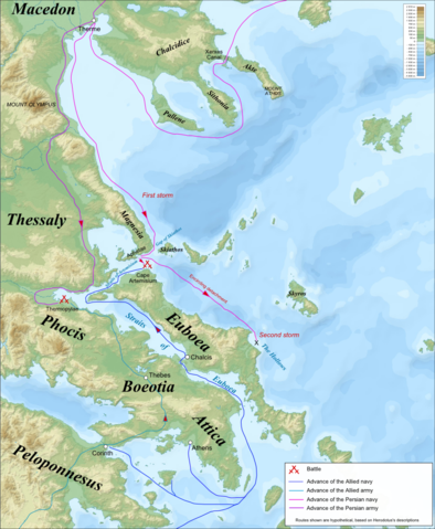
Campaign map for the Battles of Thermopylae & Artemisium (480 BC), based on the description of Herodotus. Imposed on a Bathymetic/Topographical map of the Aegean Sea.
|
| Թուական | (UTC) |
| Աղբիւր | |
| Հեղինակ |
|
| Այլ մեկնակերպներ | Derivative works of this file: Termópilas y Artemisio - es.svg |
| Սա խմբագրված պատկեր է, որը համեմատ բնօրինակին ենթարկվել է թվային մշակման։ Փոփոխությունները՝ Turned into a campaign map for the Battles of Thermopylae & Artemisium: Սկզբնական պատկերը գտնվում է այստեղ՝ Aegean Sea map bathymetry-fr.svg։ Խմբագրել է MinisterForBadTimes մասնակիցը։
|
Ես, այս աշխատանքի հեղինակային իրավունքների տերը, ներկա հրատարակում եմ սրա հետևյալ լիցենզիաների պայմաններով
This file is licensed under the Creative Commons Attribution-Share Alike 3.0 Unported, 2.5 Generic, 2.0 Generic and 1.0 Generic license.
- Դուք ազատ էք՝
- կիսել – Աշխատանքը ընդօրինակել, տարածել եւ փոխանցել
- վերափոխել – աշխատանքը յարմարեցնել
- Հետեւեալ պայմաններուն ներքոյ՝
- վերագրում – Աշխատանքը պէտք է վերագրել հեղինակին կամ արտօնատիրոջ պահանջած ձեւով (սակայն ոչ այնպէս մը որ թուայ թէ անոնք կը վաւերացնեն ձեր անոր օգտագործումը)։
- Նոյնապայման տարածում – Եթէ այս աշխատանքը ձեւափոխէք, փոխակերպէք կամ անոր հիման վրայ ստեղծէք ձերը, ապա կրնաք զայն տարածել միայն նոյնպիսի կամ համարժէք արտօնագրով։

|
Այս վաւերագիրը ընդօրինակելու, ցրուելու եւ/կամ ձեւափոխելու արտօնութիւնը տրուած է GNU Վաւերագրական ձրի արտօնագիր, 1.2 տարբերակի կամ աւելի ուշ Ձրի ծրագրային հիմնարկի կողմէ հրատարակուած պայմանագրով. առանց անփոփոխելի հատուածներու, առանց գիրքի կողքին կամ կռնակին տեղադրուած գրութիւններու:
Արտօնագրէն օրինակ մը կը գտնուի GNU Վաւերագրական ձրի արտօնագիր կոչուող հատուածին մէջ։ |
Կրնաք ընտրել ձեր փափաքած արտօնագիրը։
Original upload log
This image is a derivative work of the following images:
- File:Aegean_Sea_map_bathymetry-fr.svg licensed with Cc-by-sa-3.0,2.5,2.0,1.0, GFDL
- 2009-02-08T00:35:16Z Sting 3750x4560 (3597775 Bytes) Correcting display bug - new try - step #2
- 2009-02-08T00:29:02Z Sting 3750x4560 (410188 Bytes) Correcting display bug - new try - step #1
- 2009-02-08T00:14:50Z Sting 3750x4560 (3740562 Bytes) Correcting display bug
- 2009-02-06T07:54:54Z Future Perfect at Sunrise 3750x4560 (3742390 Bytes) null edit, re-uploading to try to force display to be reset, background image wasn't displaying
- 2009-02-06T07:52:12Z Future Perfect at Sunrise 3750x4560 (3742390 Bytes) null edit, re-uploading to try to force display to be reset, background image wasn't displaying
- 2008-09-28T21:11:49Z Sting 3750x4560 (3742390 Bytes) Completely new background using ETOPO1 data ; new standard colors ; some additional labels
- 2007-11-27T13:16:40Z Sting 3750x4560 (4078448 Bytes) Elevation on Chios
- 2007-11-26T23:25:43Z Sting 3750x4560 (4078446 Bytes) correction
- 2007-11-21T22:42:53Z Sting 3750x4560 (4079234 Bytes) Additional sea names
- 2007-11-21T20:21:26Z Sting 3750x4560 (4078039 Bytes) Additional key
- 2007-11-21T19:10:35Z Sting 3750x4560 (4072878 Bytes) {{Information |Description=Bathymetric map in French of the [[:Category:Aegean Sea|Aegean Sea]], Mediterranean Sea |Source=Own work ;Raster relief background map : [http://www2.jpl.nasa.gov/srtm NASA Shuttle Radar Topography
Uploaded with derivativeFX
Նիշքի պատմութիւն
Սեղմել օրուան/ժամին վրայ նիշքի այդ պահուն ունեցած վիճակը տեսնելու համար
| Օր/Ժամ | Մանրապատկեր | Ծաւալ | Գործածող | Մեկնաբանութիւն | |
|---|---|---|---|---|---|
| ընթացիկ | 07:53, 24 Ապրիլ 2009 | | 822 × 1000 (1,04 ՄԲ) | MinisterForBadTimes | {{Information Campaign map for the Battles of Thermopylae & Artemisium (480 BC), based on the description of Herodotus. Imposed on a Bathymetic/Topographical map of the Aegean Sea. *UTM projection; WGS84 datum ; shaded relief<br/> *Scales:<br/> **Topograp |
Նիշքի գործածութիւն
Հետեւեալ էջը կը յղուի այս նիշքին՝
Նիշքի համընդհանուր օգտագործում
Հետեւեալ ուիքիները եւս կ'օգտագործեն այս նիշքը՝
- Օգտագործումը azb.wikipedia.org կայքին վրայ
- Օգտագործումը bg.wikipedia.org կայքին վրայ
- Օգտագործումը cs.wikipedia.org կայքին վրայ
- Օգտագործումը de.wikipedia.org կայքին վրայ
- Օգտագործումը el.wikipedia.org կայքին վրայ
- Օգտագործումը en.wikipedia.org կայքին վրայ
- Օգտագործումը es.wikipedia.org կայքին վրայ
- Օգտագործումը fa.wikipedia.org կայքին վրայ
- Օգտագործումը fr.wikipedia.org կայքին վրայ
- Օգտագործումը hr.wikipedia.org կայքին վրայ
- Օգտագործումը it.wikipedia.org կայքին վրայ
- Օգտագործումը ka.wikipedia.org կայքին վրայ
- Օգտագործումը ko.wikipedia.org կայքին վրայ
- Օգտագործումը mk.wikipedia.org կայքին վրայ
- Օգտագործումը nl.wikipedia.org կայքին վրայ
- Օգտագործումը pl.wikipedia.org կայքին վրայ
- Օգտագործումը ru.wikipedia.org կայքին վրայ
- Օգտագործումը sh.wikipedia.org կայքին վրայ
- Օգտագործումը sk.wikipedia.org կայքին վրայ
- Օգտագործումը tr.wikipedia.org կայքին վրայ
- Օգտագործումը vi.wikipedia.org կայքին վրայ
- Օգտագործումը www.wikidata.org կայքին վրայ