
Պատկեր:Waldseemuller map 2.jpg

Կանխաստուգման չափը՝ 800 × 443 կէտիկ։ Այլ չափեր: 320 × 177 կէտիկ | 640 × 354 կէտիկ | 1024 × 567 կէտիկ | 1280 × 709 կէտիկ | 2560 × 1417 կէտիկ | 13 708 × 7590 կէտիկ.
Սկզբնական նիշք (13 708 × 7590 կէտիկներ, նիշքի չափը՝ 19,65 ՄԲ, MIME-տեսակը՝ image/jpeg)
Ամփոփում
| Warning | The original file is very high-resolution. It might not load properly or could cause your browser to freeze when opened at full size. |
|---|
| Նկարագրութիւն |
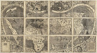
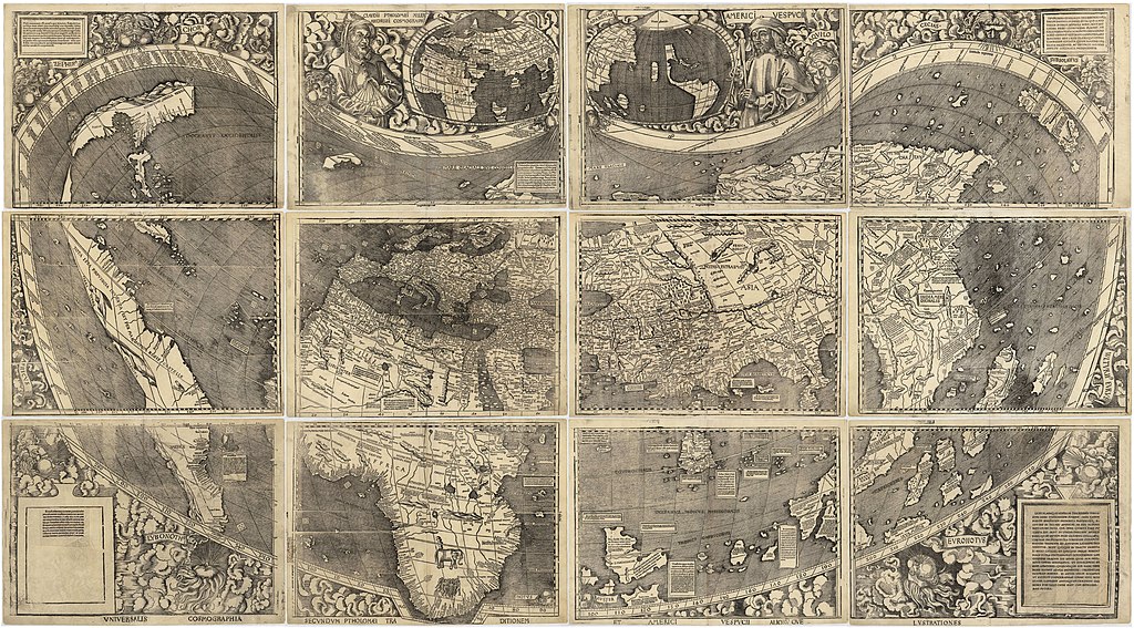
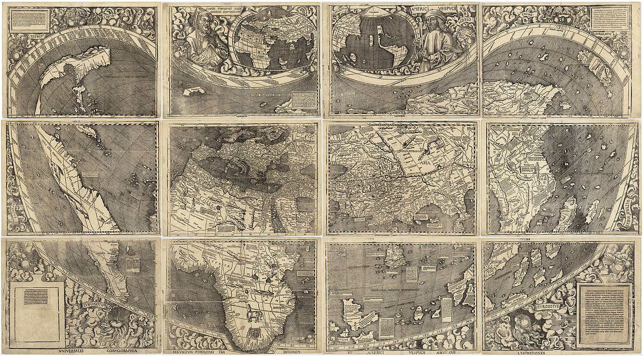
العربية: خريطة ڤالدسيمولير العائدة لِسنة 1507م. هذه الخريطة هي الأولى التي أوردت اسم «أمريكا» وأوَّل خريطة فصلت الأمريكتين عن آسيا. هذه النسخة هي الوحيدة الباقية، وقد اشترتها مكتبة الكونغرس سنة 2001م مُقابل 10 ملايين دولار أمريكي.
English: Waldseemüller map from 1507 is the first map to include the name "America" and the first to depict the Americas as separate from Asia. There is only one surviving copy of the map, which was purchased by the Library of Congress in 2001 for $10 million.
Français : Le planisphère de Waldseemüller de 1507 est la première carte mentionnant le nom "America" et la première à décrire les Amériques séparées de l'Asie. Il ne reste plus qu'une seule copie du planisphère encore existante à ce jour, acquise par la bibliothèque du Congrès en 2001 pour la somme de 10 millions de dollars. |
|||||||||||||||||||||||
| Թուական | ||||||||||||||||||||||||
| Աղբիւր | https://www.loc.gov/resource/g3200.ct000725 | |||||||||||||||||||||||
| Հեղինակ |
|
|||||||||||||||||||||||
| Այլ մեկնակերպներ |
|
|||||||||||||||||||||||


Assessment
|

Արտօնագրում
|
This work is in the public domain in its country of origin and other countries and areas where the copyright term is the author's life plus 100 years or fewer. This work is in the public domain in the United States because it was published (or registered with the U.S. Copyright Office) before January 1, 1929. | |
| This file has been identified as being free of known restrictions under copyright law, including all related and neighboring rights. | |
Նիշքի պատմութիւն
Սեղմել օրուան/ժամին վրայ նիշքի այդ պահուն ունեցած վիճակը տեսնելու համար
| Օր/Ժամ | Մանրապատկեր | Ծաւալ | Գործածող | Մեկնաբանութիւն | |
|---|---|---|---|---|---|
| ընթացիկ | 17:37, 27 Հոկտեմբեր 2008 | | 13 708 × 7590 (19,65 ՄԲ) | Jackaranga | {{Information |Description={{en|1=waldseemuller map, full page from http://memory.loc.gov/cgi-bin/map_item.pl?data=/home/www/data/gmd/gmd3/g3200/g3200/ct000725.jp2&style=gmd&itemLink=r?ammem/gmd:@field(NUMBER+@band(g3200+ct000725))&title=Universalis%20cos |
Նիշքի գործածութիւն
Այս նիշքին յղուող էջեր չկան։
Նիշքի համընդհանուր օգտագործում
Հետեւեալ ուիքիները եւս կ'օգտագործեն այս նիշքը՝
- Օգտագործումը af.wikipedia.org կայքին վրայ
- Օգտագործումը als.wikipedia.org կայքին վրայ
- Օգտագործումը ar.wikipedia.org կայքին վրայ
- الأمريكتان
- العصر الحديث
- خريطة فالدسيمولير
- استكشاف أمريكا الشمالية
- بوابة:جغرافيا/صورة مختارة/أرشيف
- ويكيبيديا:صور مختارة/رسومات وجداول وخرائط/خرائط
- ويكيبيديا:ترشيحات الصور المختارة/خريطة فالدسيمولير
- ويكيبيديا:صورة اليوم المختارة/مارس 2018
- قالب:صورة اليوم المختارة/2018-03-24
- بوابة:جغرافيا/صورة مختارة/13
- ويكيبيديا:صورة اليوم المختارة/سبتمبر 2022
- قالب:صورة اليوم المختارة/2022-09-03
- Օգտագործումը ast.wikipedia.org կայքին վրայ
- Օգտագործումը az.wikipedia.org կայքին վրայ
- Օգտագործումը bg.wikipedia.org կայքին վրայ
- Օգտագործումը bn.wikipedia.org կայքին վրայ
- Օգտագործումը br.wikipedia.org կայքին վրայ
- Օգտագործումը ca.wikipedia.org կայքին վրայ
- Օգտագործումը cs.wikipedia.org կայքին վրայ
- Օգտագործումը cy.wikipedia.org կայքին վրայ
- Օգտագործումը da.wikipedia.org կայքին վրայ
- Օգտագործումը de.wikipedia.org կայքին վրայ
- 16. Jahrhundert
- Christoph Kolumbus
- Neuzeit
- Martin Waldseemüller
- Weltkarte
- Benutzer:Mondamo/karten
- Liste historischer Weltkarten
- UNESCO-Kultur- und -Naturerbe
- Benutzer:GiFontenelle/Entwurf/Q131454, bibliothek
- Benutzer:Muhali/Waldseemüller Karte
- Benutzer:Springen/Waldseemüller-Karte
- Benutzer:Cupkake4Yoshi/History of geography
- Cosmographiae Introductio
- Օգտագործումը el.wikipedia.org կայքին վրայ
- Օգտագործումը en.wikipedia.org կայքին վրայ
Տեսնել այս նիշքի աւելի համընդհանուր օգտագործումը: