
Պատկեր:Roman Empire with dioceses in 300 AD.png
Կանխաստուգման չափը՝ 800 × 552 կէտիկ։ Այլ չափեր: 320 × 221 կէտիկ | 640 × 441 կէտիկ | 1024 × 706 կէտիկ | 1280 × 883 կէտիկ | 2052 × 1415 կէտիկ.
Սկզբնական նիշք (2052 × 1415 կէտիկներ, նիշքի չափը՝ 213 ԿԲ, MIME-տեսակը՝ image/png)

|
This map image could be re-created using vector graphics as an SVG file. This has several advantages; see Commons:Media for cleanup for more information. If an SVG form of this image is available, please upload it and afterwards replace this template with
{{vector version available|new image name}}.
It is recommended to name the SVG file “Roman Empire with dioceses in 300 AD.svg”—then the template Vector version available (or Vva) does not need the new image name parameter. |
Ամփոփում
| Նկարագրութիւն |
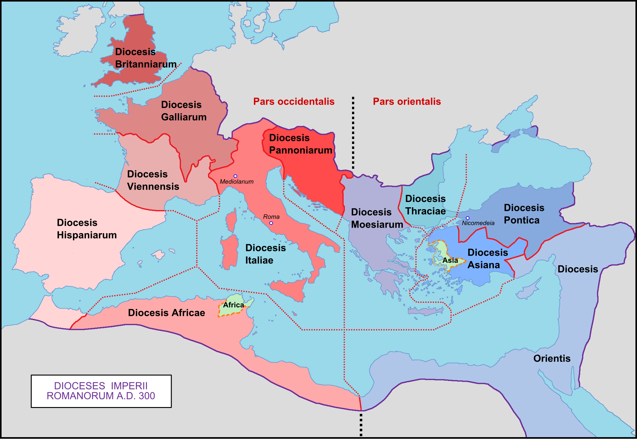
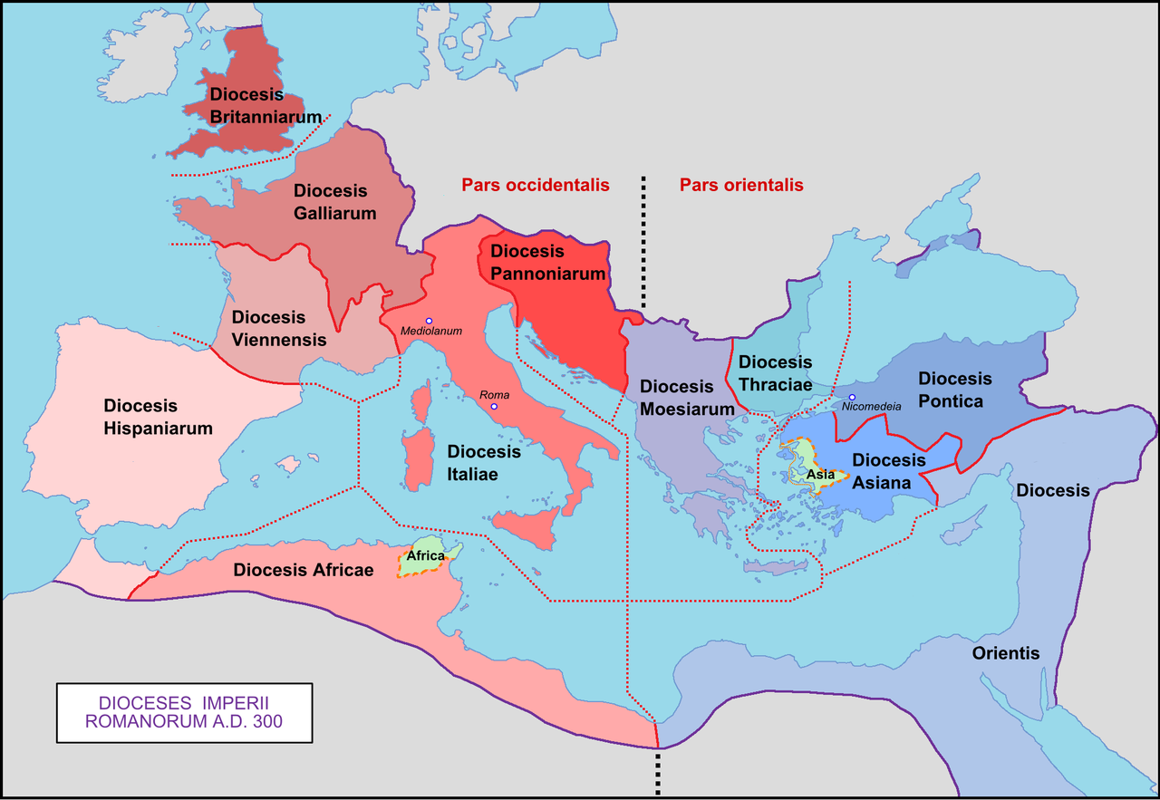
English: Map of the Roman Empire with dioceses created by Diocletien.
Français : Carte de l'Empire romain avec les diocèses créés par l'empereur Dioclétien. |
| Թուական | 03/03/09 |
| Աղբիւր | Սեփական աշխատանք |
| Հեղինակ | Mandrak |
| Այլ մեկնակերպներ |
Derivative works of this file: Prima tetrarchia Diocletianus.PNG Blank map : File:Blank Roman Empire.png []
|


Արտօնագրում
| I, the copyright holder of this work, release this work into the public domain. This applies worldwide. In some countries this may not be legally possible; if so: I grant anyone the right to use this work for any purpose, without any conditions, unless such conditions are required by law. |
Նիշքի պատմութիւն
Սեղմել օրուան/ժամին վրայ նիշքի այդ պահուն ունեցած վիճակը տեսնելու համար
| Օր/Ժամ | Մանրապատկեր | Ծաւալ | Գործածող | Մեկնաբանութիւն | |
|---|---|---|---|---|---|
| ընթացիկ | 00:29, 8 Ապրիլ 2020 | | 2052 × 1415 (213 ԿԲ) | Wikisaurus | without bottom part, because it was wrong to rewrite a file used in many articles like this |
| 12:26, 29 Նոյեմբեր 2019 |  | 2052 × 2830 (344 ԿԲ) | Claude Zygiel | Cosmetics, Chersonesos, details according with http://www.tuttitemi.altervista.org/Storia/StoriaA/DioclezianoRomolo.htm | |
| 15:54, 22 Նոյեմբեր 2019 |  | 2052 × 2830 (307 ԿԲ) | Claude Zygiel | Add below praefecturae year 395 according with Megistias's map [https://commons.wikimedia.org/wiki/File:Praetorian_Prefectures_of_the_Roman_Empire_395_AD.png] | |
| 12:34, 10 Մարտ 2009 |  | 2052 × 1414 (218 ԿԲ) | Mandrak | Erreurs corrigées. | |
| 20:03, 3 Մարտ 2009 |  | 2052 × 1414 (218 ԿԲ) | Mandrak | {{Information |Description={{en|1=Map of the Roman Empire with dioceses created by Diocletien.}} {{fr|1=Carte de l'Empire romain avec les diocèses créés par l'empereur Dioclétien.}} |Source=travail personnel (own work) |Author=Mandrak |
Նիշքի գործածութիւն
Հետեւեալ էջը կը յղուի այս նիշքին՝
Նիշքի համընդհանուր օգտագործում
Հետեւեալ ուիքիները եւս կ'օգտագործեն այս նիշքը՝
- Օգտագործումը ar.wikipedia.org կայքին վրայ
- Օգտագործումը ast.wikipedia.org կայքին վրայ
- Օգտագործումը az.wikipedia.org կայքին վրայ
- Օգտագործումը bg.wikipedia.org կայքին վրայ
- Օգտագործումը ca.wikipedia.org կայքին վրայ
- Օգտագործումը cs.wikipedia.org կայքին վրայ
- Օգտագործումը de.wikipedia.org կայքին վրայ
- 300
- Konstantin der Große
- Moesia inferior
- Dioecesis Orientis
- Dioecesis Pontica
- Dioecesis Asiana
- Dioecesis Thraciarum
- Dioecesis Moesiae
- Dioecesis Pannoniae
- Vorlage:Navigationsleiste Diözesen des Römischen Reiches
- Dioecesis Africae
- Dioecesis Britanniae
- Dioecesis Galliae
- Dioecesis Septem Provinciarum
- Dioecesis Aegypti
- Dioecesis Hispaniae
- Dioecesis Italiae
- Dioecesis Italiae Annonariae
- Dioecesis Italiae Suburbicariae
- Dioecesis Daciae
- Dioecesis Macedoniae
- Օգտագործումը el.wikipedia.org կայքին վրայ
- Օգտագործումը en.wikipedia.org կայքին վրայ
- Օգտագործումը eo.wikipedia.org կայքին վրայ
Տեսնել այս նիշքի աւելի համընդհանուր օգտագործումը: