
Պատկեր:Roman Empire full - Referenced.jpg
Կանխաստուգման չափը՝ 749 × 599 կէտիկ։ Այլ չափեր: 300 × 240 կէտիկ | 600 × 480 կէտիկ | 960 × 768 կէտիկ | 1116 × 893 կէտիկ.
Սկզբնական նիշք (1116 × 893 կէտիկներ, նիշքի չափը՝ 303 ԿԲ, MIME-տեսակը՝ image/jpeg)
Ամփոփում
| Նկարագրութիւն |
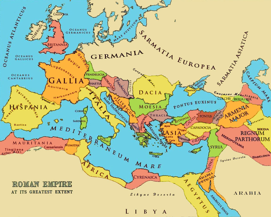
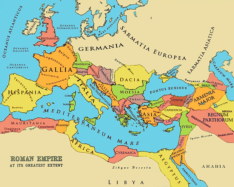
English: A referenced map of the Roman Empire at its greatest extent in the 2-3 cc. The borders of states and markings are referenced to a published historical atlas in public domain. |
| Թուական | 21 Մայիս 2010 (original upload date); 26 Յունիս 2010 (last version) |
| Աղբիւր |
|
| Հեղինակ |
Aregakn at en.wikipedia. Later versions were uploaded by Beao at en.wikipedia. |


Արտօնագրում
Aregakn at en.wikipedia, այս աշխատանքի հեղինակային իրավունքների տերը, կամավոր հրապարակում եմ այն հետևյալ լիցենզիաների պայմաններով.
Այս նիշքը տրամադրելի է Creative Commons Attribution-Share Alike 3.0 Unported արտօնագրի ներքոյ:
Վերագրում: Aregakn at en.wikipedia
- Դուք ազատ էք՝
- կիսել – Աշխատանքը ընդօրինակել, տարածել եւ փոխանցել
- վերափոխել – աշխատանքը յարմարեցնել
- Հետեւեալ պայմաններուն ներքոյ՝
- վերագրում – Աշխատանքը պէտք է վերագրել հեղինակին կամ արտօնատիրոջ պահանջած ձեւով (սակայն ոչ այնպէս մը որ թուայ թէ անոնք կը վաւերացնեն ձեր անոր օգտագործումը)։
- Նոյնապայման տարածում – Եթէ այս աշխատանքը ձեւափոխէք, փոխակերպէք կամ անոր հիման վրայ ստեղծէք ձերը, ապա կրնաք զայն տարածել միայն նոյնպիսի կամ համարժէք արտօնագրով։

|
Այս վաւերագիրը ընդօրինակելու, ցրուելու եւ/կամ ձեւափոխելու արտօնութիւնը տրուած է GNU Վաւերագրական ձրի արտօնագիր, 1.2 տարբերակի կամ աւելի ուշ Ձրի ծրագրային հիմնարկի կողմէ հրատարակուած պայմանագրով. առանց անփոփոխելի հատուածներու, առանց գիրքի կողքին կամ կռնակին տեղադրուած գրութիւններու:
Արտօնագրէն օրինակ մը կը գտնուի GNU Վաւերագրական ձրի արտօնագիր կոչուող հատուածին մէջ։ |
Կրնաք ընտրել ձեր փափաքած արտօնագիրը։
Original upload log
The original description page was here. All following user names refer to en.wikipedia.
- 2010-06-26 13:26 Beao 1116×893× (309793 bytes)
- 2010-05-29 06:05 Aregakn 1119×897× (258809 bytes) less colorful
- 2010-05-21 09:36 Aregakn 1119×897× (204488 bytes) A referenced map of the Roman Empire at it's greatest extent in the 2-3 cc. The borders of states and markings are referenced to a published historical atlas in public domain. Ref: [http://people.ucalgary.ca/~vandersp/Courses/maps/basicmap.html]
Նիշքի պատմութիւն
Սեղմել օրուան/ժամին վրայ նիշքի այդ պահուն ունեցած վիճակը տեսնելու համար
| Օր/Ժամ | Մանրապատկեր | Ծաւալ | Գործածող | Մեկնաբանութիւն | |
|---|---|---|---|---|---|
| ընթացիկ | 01:18, 3 Օգոստոս 2011 | | 1116 × 893 (303 ԿԲ) | OgreBot | (BOT): Reverting to most recent version; originally uploaded at en.wikipedia on 2010-06-26 13:26:19 by Beao |
| 01:18, 3 Օգոստոս 2011 |  | 1119 × 897 (253 ԿԲ) | OgreBot | (BOT): Uploading old version of file from en.wikipedia; originally uploaded on 2010-05-29 06:05:55 by Aregakn | |
| 01:18, 3 Օգոստոս 2011 |  | 1119 × 897 (200 ԿԲ) | OgreBot | (BOT): Uploading old version of file from en.wikipedia; originally uploaded on 2010-05-21 09:36:27 by Aregakn | |
| 21:51, 7 Յունիս 2011 |  | 1116 × 893 (303 ԿԲ) | Davius |
Նիշքի գործածութիւն
Հետեւեալ էջը կը յղուի այս նիշքին՝
Նիշքի համընդհանուր օգտագործում
Հետեւեալ ուիքիները եւս կ'օգտագործեն այս նիշքը՝
- Օգտագործումը ar.wikipedia.org կայքին վրայ
- Օգտագործումը bg.wikipedia.org կայքին վրայ
- Օգտագործումը ca.wikipedia.org կայքին վրայ
- Օգտագործումը en.wikipedia.org կայքին վրայ
- Օգտագործումը es.wikipedia.org կայքին վրայ
- Օգտագործումը fr.wiktionary.org կայքին վրայ
- Օգտագործումը hy.wikipedia.org կայքին վրայ
- Օգտագործումը it.wikipedia.org կայքին վրայ
- Օգտագործումը it.wikibooks.org կայքին վրայ
- Օգտագործումը ms.wikipedia.org կայքին վրայ
- Օգտագործումը tr.wikipedia.org կայքին վրայ