Պատկեր:First century Iudaea province.gif
Page contents not supported in other languages.

Սկզբնական նիշք(575 × 792 կէտիկներ, նիշքի չափը՝ 31 ԿԲ, MIME-տեսակը՝ image/gif)

Այս նիշքը առնուած է Ուիքիպահեստ-էն եւ կրնայ օգտագործուիլ այլ նախագիծերու մէջ։ Ուիքիպահեստ-ի մէջ անոր նիշքը նկարագրող էջիի նկարագրութիւնը ներկայացուած է ստորեւ։

This map image could be re-created using vector graphics as an SVG file. This has several advantages; see Commons:Media for cleanup for more information. If an SVG form of this image is available, please upload it and afterwards replace this template with {{vector version available|new image name}}.


It is recommended to name the SVG file “First century Iudaea province.svg”—then the template Vector version available (or Vva) does not need the new image name parameter.

Ամփոփում

Նկարագրութիւն
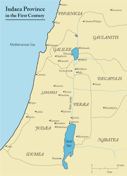
English: This is a map of first century Iudaea Province that I created using Illustrator CS2. I traced this image for the general geographic features. I then manually input data from maps found in a couple of sources.
  • Robert W. Funk and the Jesus Seminar. The Acts of Jesus. HarperSanFrancisco: 1998. p. xxiv.
  • Michael Grant. Jesus: An Historian's Review of the Gospels. Charles Scribner's Sons: 1977. p. 65-67.
  • John P. Meier. A Marginal Jew. Doubleday: 1991. p. 1:434.
Թուական 23 Մարտ 2006 (original upload date)
Աղբիւր Transferred from en.wikipedia to Commons.
Հեղինակ Andrew c at անգլերեն Ուիքիփետիա
Արտօնութիւն
(Նիշքի վերօգտագործում)
Released under the GNU Free Documentation License or CC-BY.
Այլ մեկնակերպներ العربيَّة

Արտօնագրում

Andrew c from en.wikipedia.org, սույն աշխատանքի հեղինակային իրավունքների տերը, այսուհետ այն հրատարակում է հետևյալ արտոնագրի պայմաններով՝
GNU head Այս վաւերագիրը ընդօրինակելու, ցրուելու եւ/կամ ձեւափոխելու արտօնութիւնը տրուած է GNU Վաւերագրական ձրի արտօնագիր, 1.2 տարբերակի կամ աւելի ուշ Ձրի ծրագրային հիմնարկի կողմէ հրատարակուած պայմանագրով. առանց անփոփոխելի հատուածներու, առանց գիրքի կողքին կամ կռնակին տեղադրուած գրութիւններու:

Արտօնագրէն օրինակ մը կը գտնուի GNU Վաւերագրական ձրի արտօնագիր կոչուող հատուածին մէջ։ Subject to disclaimers.

w:en:Creative Commons
վերագրում
This file is licensed under the Creative Commons Attribution 3.0 Unported license.
Վերագրում: Wikipedia User:Andrew c
Դուք ազատ էք՝
  • կիսել – Աշխատանքը ընդօրինակել, տարածել եւ փոխանցել
  • վերափոխել – աշխատանքը յարմարեցնել
Հետեւեալ պայմաններուն ներքոյ՝
  • վերագրում – Աշխատանքը պէտք է վերագրել հեղինակին կամ արտօնատիրոջ պահանջած ձեւով (սակայն ոչ այնպէս մը որ թուայ թէ անոնք կը վաւերացնեն ձեր անոր օգտագործումը)։
Public domain I, the copyright holder of this work, release this work into the public domain. This applies worldwide.
In some countries this may not be legally possible; if so:
I grant anyone the right to use this work for any purpose, without any conditions, unless such conditions are required by law.

Original upload log

The original description page was here. All following user names refer to en.wikipedia.
  • 2006-03-24 18:48 Andrew c 575×792×8 (32374 bytes) This is a map of First Century Palestine that I created using Illustrator CS2. I traced [http://commons.wikimedia.org/wiki/Image:Map_of_administrative_regions_in_Israel.png this] image for the general geographic features. I then manually input data from m
  • 2006-03-23 19:48 Andrew c 587×790×8 (30752 bytes) This is a map of First Century Palestine that I created using Illustrator CS2. I traced [http://commons.wikimedia.org/wiki/Image:Map_of_administrative_regions_in_Israel.png this] image for the general geographic features. I then manually input data from m

Captions

Add a one-line explanation of what this file represents
Judaea province in the 1st Century CE

Items portrayed in this file

պատկերված հայերեն

image/gif

checksum անգլերեն

e488e0183049d2138c916ccc7a24c107807f12b7

որոշման եղանակ հայերեն: SHA-1 անգլերեն

data size անգլերեն

32 019 Բայթ

բարձրություն հայերեն

792 փիքսել

լայնություն հայերեն

575 փիքսել

Նիշքի պատմութիւն

‎Սեղմել օրուան/ժամին վրայ նիշքի այդ պահուն ունեցած վիճակը տեսնելու համար

Օր/ԺամՄանրապատկերԾաւալԳործածողՄեկնաբանութիւն
ընթացիկ11:47, 18 Սեպտեմբեր 201111:47, 18 Սեպտեմբեր 2011 տարբերակի մանրապատկերը575 × 792 (31 ԿԲ)OnceinawhileRemoved region-name "Philistia", as incorrect
14:05, 13 Սեպտեմբեր 200714:05, 13 Սեպտեմբեր 2007 տարբերակի մանրապատկերը575 × 792 (32 ԿԲ)Liftarn{{SVG|map}} {{Information |Description=This is a map of first century en:Iudaea Province that I created using Illustrator CS2. I traced [http://commons.wikimedia.org/wiki/Image:Map_of_administrative_regions_in_Israel.png this] image for the general g
00:29, 30 Ապրիլ 200600:29, 30 Ապրիլ 2006 տարբերակի մանրապատկերը575 × 792 (32 ԿԲ)Duende~commonswikihttp://en.wikipedia.org/wiki/Image:First_century_palestine.gif

Հետեւեալ էջը կը յղուի այս նիշքին՝

Նիշքի համընդհանուր օգտագործում

Հետեւեալ ուիքիները եւս կ'օգտագործեն այս նիշքը՝

Տեսնել այս նիշքի աւելի համընդհանուր օգտագործումը: