
Պատկեր:Balkan peninsula line.jpg
Աւելի բարձր կէտաչափով տարբերակ չկայ։
Balkan_peninsula_line.jpg (558 × 530 կէտիկներ, նիշքի չափը՝ 169 ԿԲ, MIME-տեսակը՝ image/jpeg)
Ամփոփում
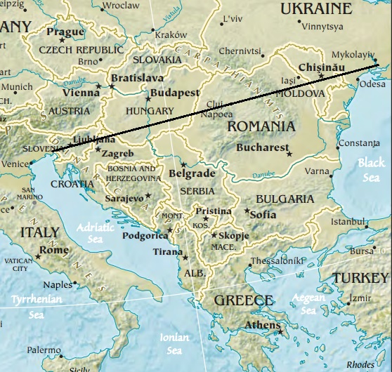
| Նկարագրութիւն | Map of the Balkan peninsula, showing the line stretching from the northernmost point of the Adriatic to the northernmost point of the Black Sea. Made from Europe map at The Central Intelligence Agency World Factbook, which is in the public domain. |
| Աղբիւր | https://www.cia.gov/library/publications/the-world-factbook//graphics/ref_maps/physical/jpg/europe.jpg |
| Հեղինակ | CIA |
| Այլ մեկնակերպներ |
|
.jpg)
Արտօնագրում
This image is in the public domain because it contains materials that originally came from the United States Central Intelligence Agency's World Factbook.
|
 |

|
This map image could be re-created using vector graphics as an SVG file. This has several advantages; see Commons:Media for cleanup for more information. If an SVG form of this image is available, please upload it and afterwards replace this template with
{{vector version available|new image name}}.
It is recommended to name the SVG file “Balkan peninsula line.svg”—then the template Vector version available (or Vva) does not need the new image name parameter. |


Նիշքի պատմութիւն
Սեղմել օրուան/ժամին վրայ նիշքի այդ պահուն ունեցած վիճակը տեսնելու համար
| Օր/Ժամ | Մանրապատկեր | Ծաւալ | Գործածող | Մեկնաբանութիւն | |
|---|---|---|---|---|---|
| ընթացիկ | 12:27, 16 Յունուար 2014 | | 558 × 530 (169 ԿԲ) | Denniss | Reverted to version as of 22:51, 26 December 2013 |
| 21:21, 15 Յունուար 2014 |  | 348 × 382 (43 ԿԲ) | Ivan VA | stop vandalizing maps | |
| 22:51, 26 Դեկտեմբեր 2013 |  | 558 × 530 (169 ԿԲ) | No More Cats | Please don't revert to outdated versions of maps | |
| 22:43, 26 Դեկտեմբեր 2013 |  | 348 × 382 (43 ԿԲ) | Nikola Smolenski | Reverted to version as of 19:13, 3 November 2006 | |
| 16:06, 17 Դեկտեմբեր 2013 |  | 558 × 530 (169 ԿԲ) | No More Cats | Map of the Balkan peninsula, showing the line stretching from the northernmost point of the Adriatic to the northernmost point of the Black Sea. Made from most recent map at [https://www.cia.gov/cia/publications/factbook/reference_maps/jpg/europe.jpg]. | |
| 19:13, 3 Նոյեմբեր 2006 |  | 348 × 382 (43 ԿԲ) | Nikola Smolenski | Map of the Balkan peninsula, showing the line stretching from the northernmost point of the Adriatic to the northernmost point of the Black Sea. Made from map at [https://www.cia.gov/cia/publications/factbook/reference_maps/jpg/europe.jpg]. |
Նիշքի գործածութիւն
Այս նիշքին յղուող էջեր չկան։