
Պատկեր:Shepherd-vicinity of Naples.jpg

Սկզբնական նիշք (836 × 539 կէտիկներ, նիշքի չափը՝ 163 ԿԲ, MIME-տեսակը՝ image/jpeg)
Ամփոփում
| Նկարագրութիւն |
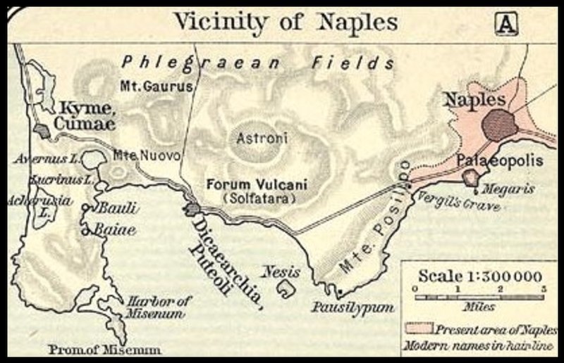
Italiano: Mappa dello Shepherd (1911) sul golfo di Napoli e poi del litorale fino a Cumae |
|||||
| Թուական | ||||||
| Աղբիւր | File:Shepherd-c-030-031.jpg | |||||
| Հեղինակ |
Historical Atlas by William R. Shepherd 1911 edition
Reference: Reference Map of Ancient Italy, Southern Part Courtesy of the University of Texas Libraries, The University of Texas at Austin. [1] |
|||||
| Արտօնութիւն (Նիշքի վերօգտագործում) |
|
|||||

![[1]](http://www.lib.utexas.edu/maps/historical/shepherd/italy_ancient_south.jpg)
Original upload log
This image is a derivative work of the following images:File:Shepherd-c-030-031.jpg
10:05, 2007 July 1 user:Accurimbono . . (366 bytes) (+366) . . (== Summary == Map of South Italy during the Roman period. Extracted from The Historical Atlas by William R. Shepherd, 1911. Original image is at http://www.lib.utexas.edu/maps/historical/shepherd_1911/shepherd-c-026-027.jpg
Նիշքի պատմութիւն
Սեղմել օրուան/ժամին վրայ նիշքի այդ պահուն ունեցած վիճակը տեսնելու համար
| Օր/Ժամ | Մանրապատկեր | Ծաւալ | Գործածող | Մեկնաբանութիւն | |
|---|---|---|---|---|---|
| ընթացիկ | 14:24, 2 Նոյեմբեր 2014 | | 836 × 539 (163 ԿԲ) | Cristiano64 | User created page with UploadWizard |
Նիշքի գործածութիւն
Հետեւեալ էջը կը յղուի այս նիշքին՝
Նիշքի համընդհանուր օգտագործում
Հետեւեալ ուիքիները եւս կ'օգտագործեն այս նիշքը՝
- Օգտագործումը en.wikipedia.org կայքին վրայ
- Օգտագործումը es.wikipedia.org կայքին վրայ
- Օգտագործումը it.wikipedia.org կայքին վրայ
- Օգտագործումը ja.wikipedia.org կայքին վրայ
- Օգտագործումը nds-nl.wikipedia.org կայքին վրայ
- Օգտագործումը nl.wikipedia.org կայքին վրայ
- Օգտագործումը sl.wikipedia.org կայքին վրայ