
Պատկեր:San Francisco earthquake.jpg
Սկզբնական նիշք (2071 × 400 կէտիկներ, նիշքի չափը՝ 315 ԿԲ, MIME-տեսակը՝ image/jpeg)
Ամփոփում
| Նկարագրութիւն |
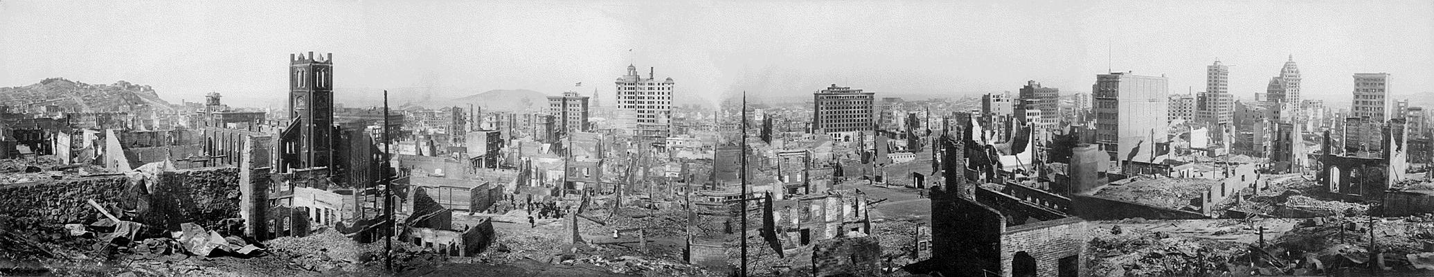
English: San Francisco earthquake 1906 - panoramic view
View of the destruction brought about by the San Francisco Earthquake, 1906 Records of the Office of the Chief Signal Officer (Army) (111-AGF-1-A-D) This is a composite panorama, meaning that it is pieced together from four separate images to give a panoramic effect. The photographer is unknown, though it may have been taken by the Army Signal Corps. It is printed on silver gelatin paper. The photo was taken from the site of the Stanford Mansion, later the Stanford Court hotel, on Powell Street, between California St. and Pine St. The square bell tower in the left frame is that of: Old Saint Mary's Church, 660 California, San Francisco, CA 94108 |
| Թուական | |
| Աղբիւր |
National Archives and Records Administration Uploaded from : www.archives.gov |
| Հեղինակ | անհայտ |
| Տեսախցիկի տեղագրություն | | Այս և ուրիշ պատկերներ իրենց տեղագրությամբ OpenStreetMap |
|---|
This work is in the public domain in the United States because it is a work prepared by an officer or employee of the United States Government as part of that person’s official duties under the terms of Title 17, Chapter 1, Section 105 of the US Code.
Note: This only applies to original works of the Federal Government and not to the work of any individual U.S. state, territory, commonwealth, county, municipality, or any other subdivision. This template also does not apply to postage stamp designs published by the United States Postal Service since 1978. (See § 313.6(C)(1) of Compendium of U.S. Copyright Office Practices). It also does not apply to certain US coins; see The US Mint Terms of Use.
|
 | |
| This file has been identified as being free of known restrictions under copyright law, including all related and neighboring rights. | ||
Նիշքի պատմութիւն
Սեղմել օրուան/ժամին վրայ նիշքի այդ պահուն ունեցած վիճակը տեսնելու համար
| Օր/Ժամ | Մանրապատկեր | Ծաւալ | Գործածող | Մեկնաբանութիւն | |
|---|---|---|---|---|---|
| ընթացիկ | 14:50, 22 Յունիս 2005 | 2071 × 400 (315 ԿԲ) | JoJan | San Francisco earthquake 1906 - panoramic view {{USGov-PD}} Uploaded from : [http://www.archives.gov/exhibit_hall/panoramic_photography/images/san_fran_earthquake.html] Credits : National Archives and Records Administration |
Նիշքի գործածութիւն
Հետեւեալ էջը կը յղուի այս նիշքին՝
Նիշքի համընդհանուր օգտագործում
Հետեւեալ ուիքիները եւս կ'օգտագործեն այս նիշքը՝
- Օգտագործումը cs.wikipedia.org կայքին վրայ
- Օգտագործումը da.wikipedia.org կայքին վրայ
- Օգտագործումը de.wikipedia.org կայքին վրայ
- Օգտագործումը en.wikipedia.org կայքին վրայ
- Օգտագործումը et.wikipedia.org կայքին վրայ
- Օգտագործումը frr.wikipedia.org կայքին վրայ
- Օգտագործումը fr.wikipedia.org կայքին վրայ
- Օգտագործումը ga.wikipedia.org կայքին վրայ
- Օգտագործումը gd.wikipedia.org կայքին վրայ
- Օգտագործումը hu.wikipedia.org կայքին վրայ
- Օգտագործումը hy.wikipedia.org կայքին վրայ
- Օգտագործումը hy.wiktionary.org կայքին վրայ
- Օգտագործումը ja.wikipedia.org կայքին վրայ
- Օգտագործումը la.wikipedia.org կայքին վրայ
- Օգտագործումը lb.wikipedia.org կայքին վրայ
- Օգտագործումը lt.wikipedia.org կայքին վրայ
- Օգտագործումը nds.wikipedia.org կայքին վրայ
- Օգտագործումը nl.wikipedia.org կայքին վրայ
- Օգտագործումը nrm.wikipedia.org կայքին վրայ
- Օգտագործումը pl.wikipedia.org կայքին վրայ
- Օգտագործումը pt.wikipedia.org կայքին վրայ
- Օգտագործումը ro.wikipedia.org կայքին վրայ
- Օգտագործումը sc.wikipedia.org կայքին վրայ