
Պատկեր:Ptolemaic-Empire 200bc.jpg
Սկզբնական նիշք (1164 × 636 կէտիկներ, նիշքի չափը՝ 1,02 ՄԲ, MIME-տեսակը՝ image/jpeg)

|
This historical map image could be re-created using vector graphics as an SVG file. This has several advantages; see Commons:Media for cleanup for more information. If an SVG form of this image is available, please upload it and afterwards replace this template with
{{vector version available|new image name}}.
It is recommended to name the SVG file “Ptolemaic-Empire 200bc.svg”—then the template Vector version available (or Vva) does not need the new image name parameter. |


Ամփոփում
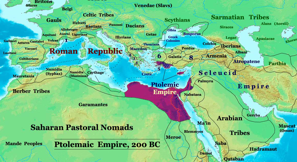
| Նկարագրութիւն | The Ptolemaic Kingdom of Egypt in 200 BC. |
| Աղբիւր | Սեփական աշխատանք |
| Հեղինակ | Thomas Lessman (Contact!) |
| Արտօնութիւն (Նիշքի վերօգտագործում) |
Ես, սույն աշխատանքի հեղինակային իրավունքների տերը, այսուհետ այն հրատարակում եմ հետևյալ արտոնագրի ներքո։ Այս նիշքը տրամադրելի է Creative Commons Attribution-Share Alike 3.0 Unported արտօնագրի ներքոյ:
|
| Այլ մեկնակերպներ |
Derivative works of this file: Ptolemaic-Empire 200bcARABIC.JPG see below |
Author: Thomas A. Lessman. Source URL: http://www.ThomasLessman.com/History/images/East-Hem_200bc.jpg. Image was created by me (Thomas Lessman) based on my map of Eastern Hemisphere in 200 BC.
Map Summary

Original Source URL: http://www.thomaslessman.com/History/images/East-Hem_200bc.jpg
This map is a zoomed-in version of Thomas Lessman's map of the
East-Hem 200bc.jpg (also available at www.WorldHistoryMaps.info).
Highlighted areas represent lands of the Ptolemaic Kingdom of Egypt in the year 200 BC, during the reign of Ptolemy V Epiphanes (before the 2nd invasion of Antiochus III).
Map Source References
Remember, sources often conflict with each other. This map is only as accurate as the information that is available to me. To report any errors or to help further this work, please click here, or email Thomas Lessman at talessman@yis.us
References for information contained in this map:
Other Maps by Thomas Lessman
| Maps of the eastern hemisphere showing history
Bold dates are available on Wikimedia or Wikipedia. | ||
| Primeval | ||
| Ancient
|
·| 600 BC | 550 BC | 527 BC | 500 BC |
400 BC | ·| 1 AD | 50 AD | 100 AD | 200 AD | 300 AD | | |
| Medieval |
·| 500 AD | 565 AD | 600 AD | 700 AD | | |
| Modern |
·| 1500 AD | · * For historical maps of the whole world, | |
Other Info
Նիշքի պատմութիւն
Սեղմել օրուան/ժամին վրայ նիշքի այդ պահուն ունեցած վիճակը տեսնելու համար
| Օր/Ժամ | Մանրապատկեր | Ծաւալ | Գործածող | Մեկնաբանութիւն | |
|---|---|---|---|---|---|
| ընթացիկ | 20:06, 3 Փետրուար 2010 | | 1164 × 636 (1,02 ՄԲ) | Malus Catulus | I missed a spot |
| 20:01, 3 Փետրուար 2010 |  | 1164 × 636 (1 ՄԲ) | Malus Catulus | Removed redundant info according to commons norms | |
| 08:15, 20 Մայիս 2008 |  | 1164 × 636 (886 ԿԲ) | Talessman | {{Information |Description= |Source=self-made |Date= |Author= Talessman |Permission= |other_versions= }} Category:Hellenistic age Category:Maps of Asian history Category:Maps of Ancient Greece Category:Seleucid dynasty |
Նիշքի գործածութիւն
Հետեւեալ էջը կը յղուի այս նիշքին՝
Նիշքի համընդհանուր օգտագործում
Հետեւեալ ուիքիները եւս կ'օգտագործեն այս նիշքը՝
- Օգտագործումը ar.wikipedia.org կայքին վրայ
- Օգտագործումը ast.wikipedia.org կայքին վրայ
- Օգտագործումը be.wikipedia.org կայքին վրայ
- Օգտագործումը bg.wikipedia.org կայքին վրայ
- Օգտագործումը de.wikipedia.org կայքին վրայ
- Օգտագործումը el.wikipedia.org կայքին վրայ
- Օգտագործումը en.wikipedia.org կայքին վրայ
- Օգտագործումը eo.wikipedia.org կայքին վրայ
- Օգտագործումը es.wikipedia.org կայքին վրայ
- Օգտագործումը fa.wikipedia.org կայքին վրայ
- Օգտագործումը fr.wikipedia.org կայքին վրայ
- Օգտագործումը gl.wikipedia.org կայքին վրայ
- Օգտագործումը he.wikipedia.org կայքին վրայ
- Օգտագործումը hu.wikipedia.org կայքին վրայ
- Օգտագործումը hy.wikipedia.org կայքին վրայ
- Օգտագործումը id.wikipedia.org կայքին վրայ
- Օգտագործումը it.wikipedia.org կայքին վրայ
- Օգտագործումը ja.wikipedia.org կայքին վրայ
- Օգտագործումը ko.wikipedia.org կայքին վրայ
- Օգտագործումը la.wikipedia.org կայքին վրայ
- Օգտագործումը lt.wikipedia.org կայքին վրայ
- Օգտագործումը mg.wikipedia.org կայքին վրայ
- Օգտագործումը ms.wikipedia.org կայքին վրայ
- Օգտագործումը no.wikipedia.org կայքին վրայ
- Օգտագործումը pnb.wikipedia.org կայքին վրայ
- Օգտագործումը pt.wikipedia.org կայքին վրայ
- Օգտագործումը ru.wikipedia.org կայքին վրայ
- Օգտագործումը sco.wikipedia.org կայքին վրայ
- Օգտագործումը sh.wikipedia.org կայքին վրայ
- Օգտագործումը sl.wikipedia.org կայքին վրայ
- Օգտագործումը sr.wikipedia.org կայքին վրայ
- Օգտագործումը sv.wikipedia.org կայքին վրայ
Տեսնել այս նիշքի աւելի համընդհանուր օգտագործումը: