
Պատկեր:Piles of Salt Salar de Uyuni Bolivia Luca Galuzzi 2006 a.jpg
Սկզբնական նիշք (2000 × 1320 կէտիկներ, նիշքի չափը՝ 892 ԿԲ, MIME-տեսակը՝ image/jpeg)
|

Այս պատկերը ընտրված է եղել որպես օրվա պատկեր 19 Հունիս 2007 թվականի համար: Պատկերը ունի հետևյալ նկարագրում՝ Այլ լեզուներ՝
Afrikaans: Southopies bevorder verdamping in die Salar de Uyuni, Bolivië Español: Montículos de sal en el Salar de Uyuni, Bolivia. (Foto: Luca Galuzzi - http://www.galuzzi.it) Français : Récolte du sel dans le Salar de Uyuni, en Bolivie. (Photo : Luca Galuzzi - http://www.galuzzi.it) Nederlands: Zoutheuvels voor de zoutwinning op de Salar de Uyuni in Bolivia. (Foto: Luca Galuzzi - http://www.galuzzi.it) Polski: Kopce solne w solnisku Salar de Uyuni, w Boliwii (fot. Luca Galuzzi - http://www.galuzzi.it) Беларуская: Саляныя капцы на саляным возеры Салар дэ Ююні (Балівія) |
| Նկարագրութիւն |
العربية: تراكُمات ملحيَّة في سالار دو أويوني، في بوليڤيا. تُعتبرُ سالار دو أويوني أكبر (12 000 كلم²) وأعلى (3 700 م) بُحيرة ملحيَّة على سطح الأرض، فهي تفوقُ بُحيرة بونيڤيل الملحيَّة حجمًا بِحوالي. 25 مرَّة. وهي كُل ما تبقَّى من بُحيرةٍ قبتاريخيَّة تُحيطُ بها الجبال دون أن يكون لها أيَّة مصارف أو مجارٍ. يُجمعُ الملح من هذا المكان بالطُرق التقليديَّة: يُكشطُ الملح ويُجمعُ في أكوامٍ صغيرة كي يتبخَّر منهُ الماء وكي يسهل تجميعه ونقله، ثُمَّ يتم تجفيفه فوق النار، وأخيرًا يُخصَّبُ بِاليُود.
Deutsch: Salzhügel im Salar de Uyuni in Bolivien. Der Salar de Uyuni ist der größte (12.000 km²) und höchste (3700m) Salzsee der Welt, ungefähr 25 mal so groß wie die Bonneville Salt Flats. Er ist entstanden aus einem durch Berge eingeschlossenen prähistorischen See ohne Abfluß. Salz wird in der traditionellen Methode gewonnen: Das Salz wird zu kleinen Hügeln zusammengerecht zur Wasserevaporation und zum leichteren Transport, danach wird es über Feuer getrocknet und mit Jod angereichert.
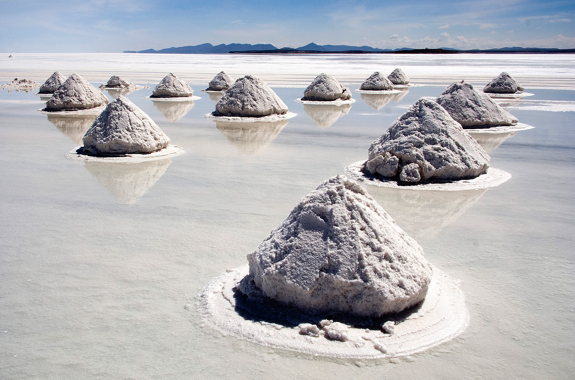
English: Salt mounds in Salar de Uyuni, Bolivia. The Salar de Uyuni is the world's largest (12 000 km²) and highest (3 700 m) salt flat, ca. 25 times as large as the Bonneville Salt Flats. It's the remnant of a prehistoric lake surrounded by mountains without drainage outlets. Salt is harvested in the traditional method: the salt is scraped into small mounds for water evaporation and easier transportation, dried over fire, and finally enriched with iodine.
Español: Pilas de sal en el Salar de Uyuni (Bolivia), la mayor salina del mundo. Es el remanente de un lago prehistórico rodeado por montañas sin salidas de drenaje. La sal se cosecha con el método tradicional: se amontona enpequeñas pilas para que se evapore el agua y para transportarla fácilmente, secada al fuego, y enriquecida finalmente con yodo.
Français : Récolte du sel dans le Salar de Uyuni, en Bolivie. Le Salar de Uyuni (3 700 m) couvre une surface de 12 000 km² soit la taille de l'Île-de-France, ce qui en fait le désert de sel le plus grand et le plus élevé du monde. Ce désert résulte de l'assèchement d'un lac préhistorique entouré de montagnes et privé d'émissaire. La récolte du sel se fait de façon traditionelle : le sel récolté est façonné en monticules, ce qui favorise l'évaporation de l'eau qu'il contient, et facilite son transport. Le sel est ensuite séché au feu, et enfin enrichi en iode.
Italiano: Raccolta del sale nel Salar de Uyuni, Bolivia. Il Salar de Uyuni è il più grande (12.000 km²) e più in alto (3.700 m) deserto di sale del mondo, con una superficie più estesa dell'Abruzzo. Deriva dal prosciugamento di un lago salato preistorico circondato dalle montagne e senza drenaggio. Il sale viene raccolto in modo tradizionale, accumulato in piccole montagnette in modo che l'acqua evapori poi viene asciugato sul fuoco e arricchito con iodio.
日本語: ボリビア、ウユニ塩湖の製塩用の塩の山。ここでは湖の塩を削り取り小山を作って乾燥させるという伝統的手法で塩が生産されている。ウユニ塩湖は世界で最も大きく、最も標高の高い塩類平原で (12 000 km²、3 700 m)、ボンネビル・ソルトフラッツの約25倍の大きさにあたる。
Türkçe: Bolivya'da bulunan ve Dünya'nın en büyük tuz göllerinden biri olan Salar de Uyuni'deki tuz tepecikleri. |
||
| Թուական | |||
| Աղբիւր | Photo taken by (Luca Galuzzi) * http://www.galuzzi.it | ||
| Հեղինակ | Luca Galuzzi (Lucag), edit by Trialsanderrors | ||
| Արտօնութիւն (Նիշքի վերօգտագործում) |
Ես, սույն աշխատանքի հեղինակային իրավունքների տերը, այսուհետ այն հրատարակում եմ հետևյալ արտոնագրի ներքո։ This file is licensed under the Creative Commons Attribution-Share Alike 2.5 Generic license.
|
||
| Այլ մեկնակերպներ |
 |

| Տեսախցիկի տեղագրություն | | Այս և ուրիշ պատկերներ իրենց տեղագրությամբ OpenStreetMap |
|---|
Սա խմբագրված պատկեր է, որը համեմատ բնօրինակին ենթարկվել է թվային մշակման։ Փոփոխությունները՝ Made for Wikipedia:
|
Նիշքի պատմութիւն
Սեղմել օրուան/ժամին վրայ նիշքի այդ պահուն ունեցած վիճակը տեսնելու համար
| Օր/Ժամ | Մանրապատկեր | Ծաւալ | Գործածող | Մեկնաբանութիւն | |
|---|---|---|---|---|---|
| ընթացիկ | 07:30, 22 Մարտ 2007 | | 2000 × 1320 (892 ԿԲ) | Trialsanderrors | {{Information |Description={{en|Piles of Salt on the Salar de Uyuni, Bolivia.}} {{it|Raccolta del sale nel Salar de Uyuni, Bolivia.}} |Source=Photo taken by (Luca Galuzzi) * http://www.galuzzi.it |Date=2006-04-14 |Aut |
Նիշքի գործածութիւն
Հետեւեալ էջը կը յղուի այս նիշքին՝
Նիշքի համընդհանուր օգտագործում
Հետեւեալ ուիքիները եւս կ'օգտագործեն այս նիշքը՝
- Օգտագործումը af.wikipedia.org կայքին վրայ
- Օգտագործումը ar.wikipedia.org կայքին վրայ
- سالار دو أويوني
- ملح الطعام
- ويكيبيديا:صور مختارة/أماكن/مناظر طبيعية
- تاريخ الملح
- ويكيبيديا:ترشيحات الصور المختارة/بحيرة ملحية
- ويكيبيديا:صورة اليوم المختارة/أبريل 2016
- قالب:صورة اليوم المختارة/2016-04-14
- بوابة:مطاعم وطعام/مقالة مختارة
- بوابة:مطاعم وطعام/مقالة مختارة/أرشيف
- بوابة:مطاعم وطعام/مقالة وصورة
- بوابة:مطاعم وطعام/مقالة مختارة/2
- ويكيبيديا:صورة اليوم المختارة/يونيو 2017
- قالب:صورة اليوم المختارة/2017-06-25
- ويكيبيديا:صورة اليوم المختارة/يونيو 2019
- قالب:صورة اليوم المختارة/2019-06-05
- هندسة العمارة البوليفية
- ويكيبيديا:صورة اليوم المختارة/يناير 2022
- قالب:صورة اليوم المختارة/2022-01-12
- بحيرة جافة
- طعام الإنسان
- Օգտագործումը ast.wikipedia.org կայքին վրայ
- Օգտագործումը av.wikipedia.org կայքին վրայ
- Օգտագործումը ay.wikipedia.org կայքին վրայ
- Օգտագործումը ba.wikipedia.org կայքին վրայ
- Օգտագործումը be.wikipedia.org կայքին վրայ
- Օգտագործումը bn.wikipedia.org կայքին վրայ
- Օգտագործումը br.wikipedia.org կայքին վրայ
- Օգտագործումը ca.wikipedia.org կայքին վրայ
- Օգտագործումը ceb.wikipedia.org կայքին վրայ
- Օգտագործումը crh.wikipedia.org կայքին վրայ
- Օգտագործումը cs.wikipedia.org կայքին վրայ
Տեսնել այս նիշքի աւելի համընդհանուր օգտագործումը: