
Պատկեր:Moyen Orient Amarna 1.svg

Սկզբնական նիշք (SVG նիշք, անուանապէս 1885 × 1354 կէտիկ, նիշքի չափը՝ 4,02 ՄԲ)

|
Այս SVG ֆայլ օգտագործում է զետեղված տեքստ, որը կարելի է հեշտ թարգմանել ձեր լեզվի վրա using [toolforge:svgtranslate/File:Moyen_Orient_Amarna_1.svglink this automated tool]: Իմացեք ավելին: You can also download it and translate it manually using a text editor. |
| Նկարագրութիւն |
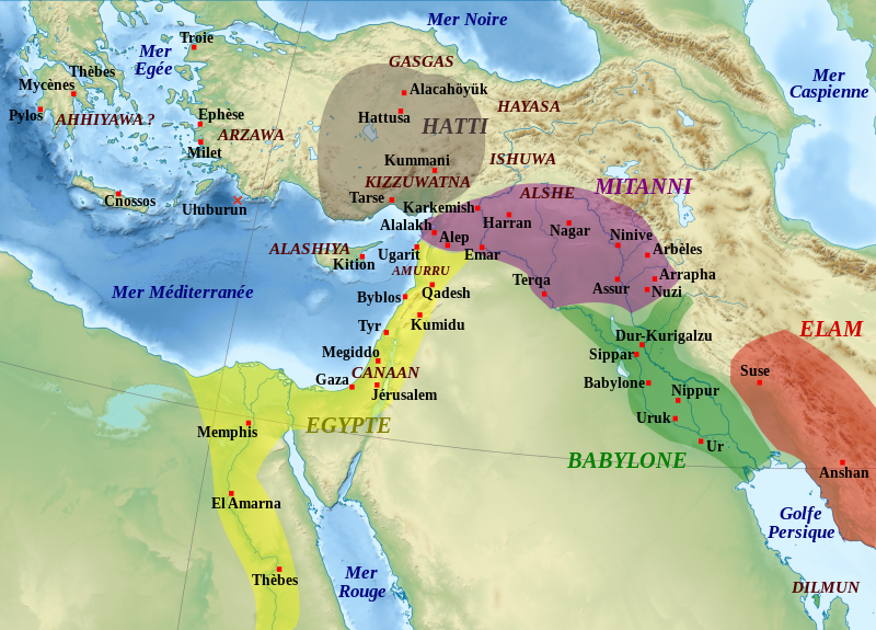
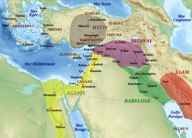
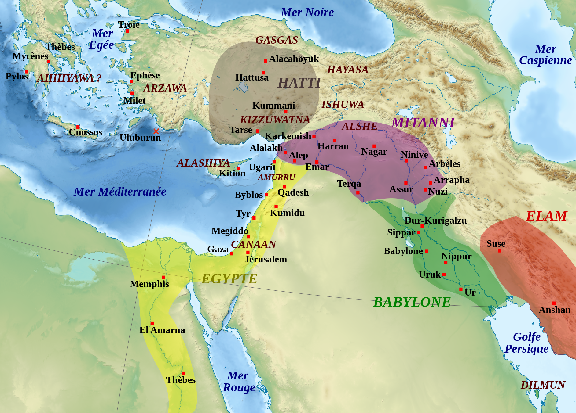
English: Map of the Middle East in the beginning of the Amarna letters period, the first half of the 14th century BC. The extension of the dominions of the great kingdoms is approximate. Remarks : the extension of the Arzawa is not shown because of its uncertainty, it may have covered the main part of Western Anatolia ; the Ahhiyawa are here supposed to be the "Mycaneans" ; the extension of Elam is very approximate. Español: Mapa de l'Orient Mitjà al començament del període de les cartes d'Amarna, la primera meitat del segle XIV aC. L'extensió dels dominis dels grans regnes és aproximada. Observacions: l'extensió de l'Arzawa no es mostra a causa de la seva incertesa, podria haver cobert la part principal de l'Anatòlia occidental ; els Ahhiyawa aquí se suposa que són els "micènics"; l'extensió d'Elam és molt aproximada. Français : Carte de la situation politique du Moyen-Orient au début de la période des Lettres d'Amarna, première moitié du XIVe siècle av. J.-C. L'extension des zones dominées par les grands royaumes est approximative. Remarques : l'extension de l'Arzawa n'est pas notée car trop incertaine, mais doit couvrir la majeure partie de l'Anatolie occidentale ; les Ahhiyawa sont considérés comme correspondant à la civilisation mycénienne ; l'extension de l'Elam est approximative. |
| Թուական | (UTC) |
| Աղբիւր | |
| Հեղինակ |
|
| Այլ մեկնակերպներ |
File:Moyen Orient Amarna 1.svg has 2 translations.
Other related versions: []
|


|
|
Այս SVG ֆայլ օգտագործում է զետեղված տեքստ, որը կարելի է հեշտ թարգմանել ձեր լեզվի վրա using [toolforge:svgtranslate/File:Moyen_Orient_Amarna_1.svglink this automated tool]: Իմացեք ավելին: You can also download it and translate it manually using a text editor. |
This file is translated using SVG For most Wikipedia projects, you can embed the file normally (without a To translate the text into your language, you can use the SVG Translate tool. Alternatively, you can download the file to your computer, add your translations using whatever software you're familiar with, and re-upload it with the same name. You will find help in Graphics Lab if you're not sure how to do this. |
| Սա խմբագրված պատկեր է, որը համեմատ բնօրինակին ենթարկվել է թվային մշակման։ Փոփոխությունները՝ Ajout des royaumes, sites archéologiques et régions.: Սկզբնական պատկերը գտնվում է այստեղ՝ Middle East topographic map-blank.svg։ Խմբագրել է Zunkir մասնակիցը։
|
- Դուք ազատ էք՝
- կիսել – Աշխատանքը ընդօրինակել, տարածել եւ փոխանցել
- վերափոխել – աշխատանքը յարմարեցնել
- Հետեւեալ պայմաններուն ներքոյ՝
- վերագրում – Աշխատանքը պէտք է վերագրել հեղինակին կամ արտօնատիրոջ պահանջած ձեւով (սակայն ոչ այնպէս մը որ թուայ թէ անոնք կը վաւերացնեն ձեր անոր օգտագործումը)։
- Նոյնապայման տարածում – Եթէ այս աշխատանքը ձեւափոխէք, փոխակերպէք կամ անոր հիման վրայ ստեղծէք ձերը, ապա կրնաք զայն տարածել միայն նոյնպիսի կամ համարժէք արտօնագրով։

|
Այս վաւերագիրը ընդօրինակելու, ցրուելու եւ/կամ ձեւափոխելու արտօնութիւնը տրուած է GNU Վաւերագրական ձրի արտօնագիր, 1.2 տարբերակի կամ աւելի ուշ Ձրի ծրագրային հիմնարկի կողմէ հրատարակուած պայմանագրով. առանց անփոփոխելի հատուածներու, առանց գիրքի կողքին կամ կռնակին տեղադրուած գրութիւններու:
Արտօնագրէն օրինակ մը կը գտնուի GNU Վաւերագրական ձրի արտօնագիր կոչուող հատուածին մէջ։ |
Original upload log
This image is a derivative work of the following images:
- File:Middle_East_topographic_map-blank.svg licensed with Cc-by-sa-3.0,2.5,2.0,1.0, GFDL
- 2010-11-03T17:52:56Z Sémhur 3097x1938 (10510751 Bytes) == {{int:filedesc}} == {{Information |Description={{Multilingual description |en= Blank physical map of the [[:en:Middle East|Middle East]] |fr= Carte physique vierge du [[:fr:Moyen-Orient|Moyen-Orient]]. }} |Source={{own}}.
Uploaded with derivativeFX
Նիշքի պատմութիւն
Սեղմել օրուան/ժամին վրայ նիշքի այդ պահուն ունեցած վիճակը տեսնելու համար
| Օր/Ժամ | Մանրապատկեր | Ծաւալ | Գործածող | Մեկնաբանութիւն | |
|---|---|---|---|---|---|
| ընթացիկ | 18:58, 22 Փետրուար 2024 | | 1885 × 1354 (4,02 ՄԲ) | Manlleus | File uploaded using svgtranslate tool (https://svgtranslate.toolforge.org/). Added translation for ca. |
| 17:47, 22 Փետրուար 2024 |  | 1885 × 1354 (3,96 ՄԲ) | Manlleus | fixed text labels for translation | |
| 12:47, 19 Հոկտեմբեր 2020 |  | 1885 × 1354 (3,97 ՄԲ) | Rebblumstein | Reverted to version as of 14:58, 6 March 2016 (UTC) (Until I fix it more thoroughly) | |
| 12:02, 19 Հոկտեմբեր 2020 |  | 1885 × 1354 (3,97 ՄԲ) | Rebblumstein | Removed more nested <tspan> elements | |
| 11:50, 19 Հոկտեմբեր 2020 |  | 1885 × 1354 (3,97 ՄԲ) | Rebblumstein | Removed nested <tspan> elements | |
| 14:58, 6 Մարտ 2016 |  | 1885 × 1354 (3,97 ՄԲ) | Geagea | Reverted to version as of 20:28, 28 October 2011 (UTC) | |
| 14:57, 6 Մարտ 2016 |  | 1885 × 1354 (3,97 ՄԲ) | Geagea | Editing SVG source code using User:Rillke/SVGedit.js; upload handled by User:Rillke/MwJSBot.js | |
| 20:28, 28 Հոկտեմբեր 2011 |  | 1885 × 1354 (3,97 ՄԲ) | Zunkir | Police et remaniements mineurs. | |
| 19:30, 14 Նոյեմբեր 2010 |  | 1885 × 1354 (3,96 ՄԲ) | Zunkir | {{Information |Description={{Multilingual description |fr= Carte de la situation politique du Moyen-Orient au début de la période des Lettres d'Amarna, première moitié du XIVe siècle av. J.-C. L'extension des zones dominées par les grands royaumes e |
Նիշքի գործածութիւն
Հետեւեալ էջը կը յղուի այս նիշքին՝
Նիշքի համընդհանուր օգտագործում
Հետեւեալ ուիքիները եւս կ'օգտագործեն այս նիշքը՝
- Օգտագործումը ar.wikipedia.org կայքին վրայ
- Օգտագործումը ca.wikipedia.org կայքին վրայ
- Օգտագործումը de.wikipedia.org կայքին վրայ
- Օգտագործումը en.wikipedia.org կայքին վրայ
- Օգտագործումը es.wikipedia.org կայքին վրայ
- Օգտագործումը fr.wikipedia.org կայքին վրայ
- Pharaon
- Mésopotamie
- Hittites
- Kizzuwatna
- Hébreux
- Histoire de l'Irak
- Lettres d'Amarna
- Liste des souverains de Babylone
- Assur-uballit Ier
- Histoire de la Mésopotamie
- Proche-Orient ancien
- Diplomatie dans le Proche-Orient ancien
- Mittani
- Histoire des Hittites
- Utilisateur:Zunkir/POA autres
- Utilisateur:Soutekh67/Bac à sable (Egypte)
- Amurru (royaume)
- Utilisateur:Zunkir/cartothèque
Տեսնել այս նիշքի աւելի համընդհանուր օգտագործումը: