
Պատկեր:Location of Lugansk People's Republic.png
Կանխաստուգման չափը՝ 800 × 586 կէտիկ։ Այլ չափեր: 320 × 234 կէտիկ | 640 × 469 կէտիկ | 1024 × 750 կէտիկ | 1280 × 938 կէտիկ | 1694 × 1241 կէտիկ.
Սկզբնական նիշք (1694 × 1241 կէտիկներ, նիշքի չափը՝ 956 ԿԲ, MIME-տեսակը՝ image/png)

|
This locator map image could be re-created using vector graphics as an SVG file. This has several advantages; see Commons:Media for cleanup for more information. If an SVG form of this image is available, please upload it and afterwards replace this template with
{{vector version available|new image name}}.
It is recommended to name the SVG file “Location of Lugansk People's Republic.svg”—then the template Vector version available (or Vva) does not need the new image name parameter. |
Ամփոփում
| Նկարագրութիւն |
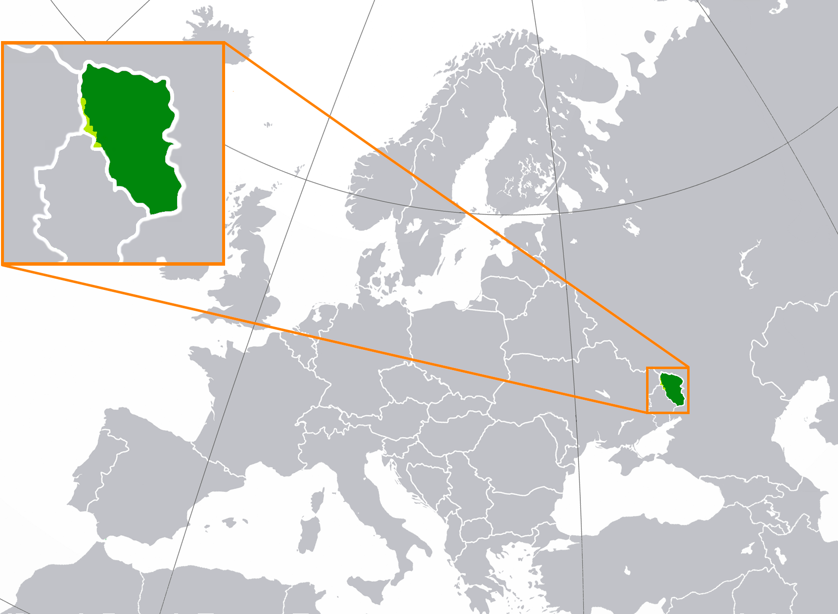
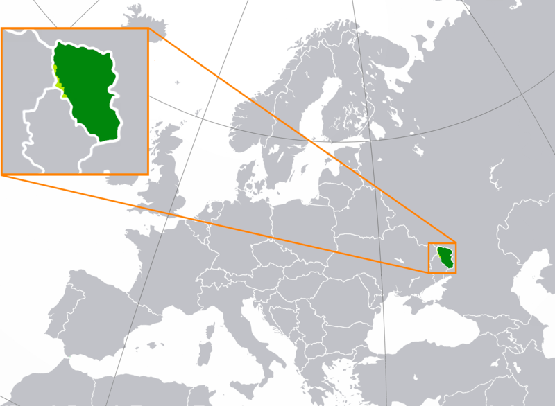
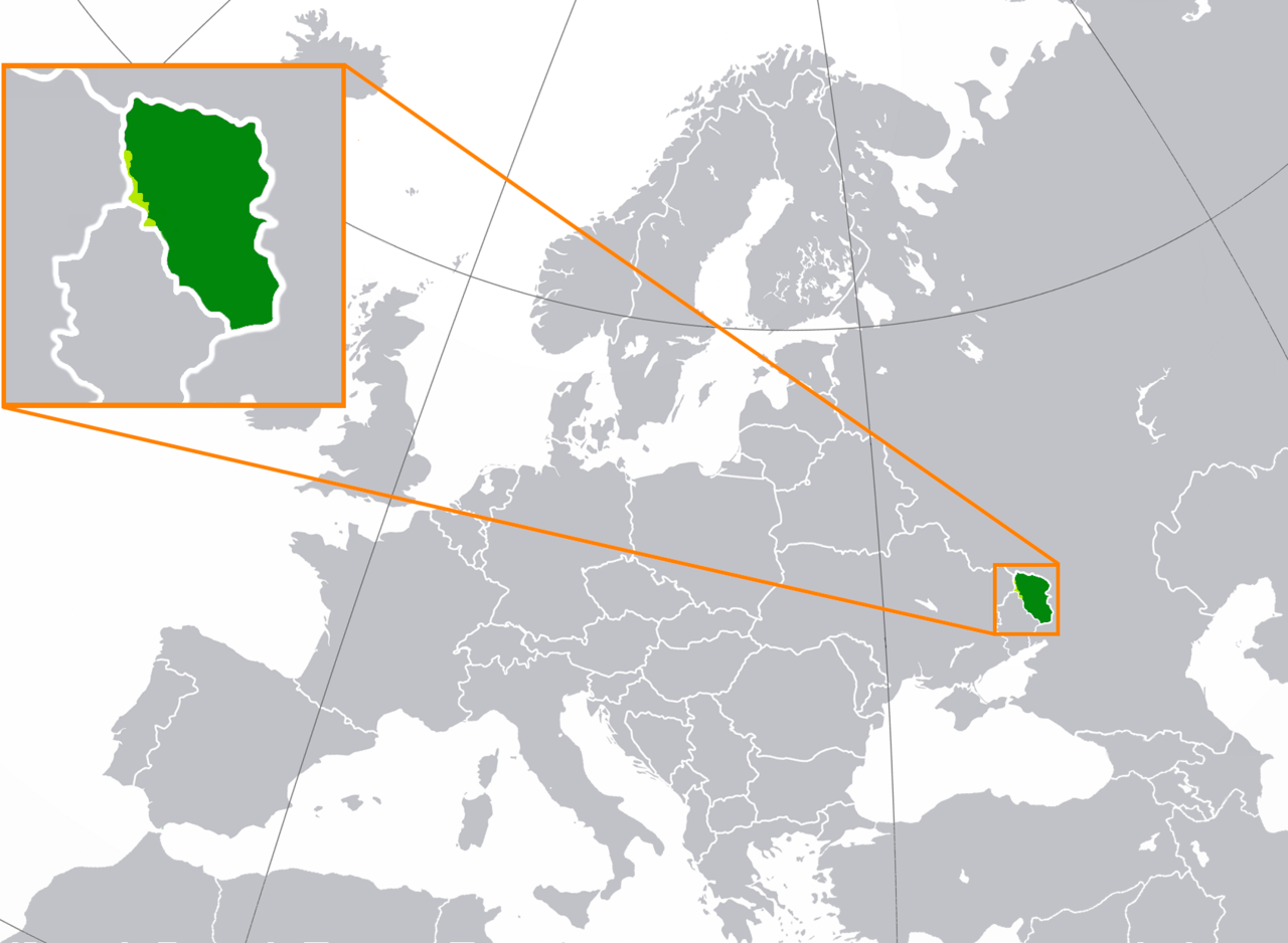
Русский: Луганская Народная Республика на карте Европы
English: territory controlled by the self-proclaimed Lugansk People's Republic (dark green) inside of the Luhansk Oblast (light green)
Français : Territoire contrôlé par la République populaire de Lougansk (vert foncé) à l'intérieur de l'oblast de Louhansk (vert clair)
Deutsch: Kontrollierte Gebiete der nicht anerkannten de:Volksrepublik Lugansk (dunkelgrün) innerhalb der de:Oblast Luhansk (hellgrün) |
| Թուական | |
| Աղբիւր | Սեփական աշխատանք |
| Հեղինակ | Nicolay Sidorov |
| Այլ մեկնակերպներ | Derivative works of this file: Location of Lugansk People's Republic (before 2022 invasion).png |
.png)

|
This file may be updated to reflect new information. If you wish to use a specific version of the file without new updates being mirrored, please upload the required version as a separate file. |
Արտօնագրում
Ես, սույն աշխատանքի հեղինակային իրավունքների տերը, այսուհետ այն հրատարակում եմ հետևյալ արտոնագրի ներքո։
Այս նիշքը տրամադրելի է Creative Commons Attribution-Share Alike 3.0 Unported արտօնագրի ներքոյ:
- Դուք ազատ էք՝
- կիսել – Աշխատանքը ընդօրինակել, տարածել եւ փոխանցել
- վերափոխել – աշխատանքը յարմարեցնել
- Հետեւեալ պայմաններուն ներքոյ՝
- վերագրում – Աշխատանքը պէտք է վերագրել հեղինակին կամ արտօնատիրոջ պահանջած ձեւով (սակայն ոչ այնպէս մը որ թուայ թէ անոնք կը վաւերացնեն ձեր անոր օգտագործումը)։
- Նոյնապայման տարածում – Եթէ այս աշխատանքը ձեւափոխէք, փոխակերպէք կամ անոր հիման վրայ ստեղծէք ձերը, ապա կրնաք զայն տարածել միայն նոյնպիսի կամ համարժէք արտօնագրով։
Նիշքի պատմութիւն
Սեղմել օրուան/ժամին վրայ նիշքի այդ պահուն ունեցած վիճակը տեսնելու համար
| Օր/Ժամ | Մանրապատկեր | Ծաւալ | Գործածող | Մեկնաբանութիւն | |
|---|---|---|---|---|---|
| ընթացիկ | 03:06, 28 Յունուար 2023 | | 1694 × 1241 (956 ԿԲ) | DinoSoupCanada | ...still needs to be updated once in a while |
| 11:45, 28 Նոյեմբեր 2022 |  | 1694 × 1241 (796 ԿԲ) | Durranistan | change map per [https://commons.wikimedia.org/wiki/File:War_for_donbass_24-6-2022.svg war in Donbas] | |
| 19:36, 13 Նոյեմբեր 2022 |  | 1694 × 1241 (765 ԿԲ) | DinoSoupCanada | Since the article is repurposed as a disputed subject of Russia, then it's fine to edit again. | |
| 13:35, 10 Հոկտեմբեր 2022 |  | 1694 × 1241 (733 ԿԲ) | DinoSoupCanada | Reverted to version as of 01:16, 1 October 2022 (UTC) | |
| 22:02, 6 Հոկտեմբեր 2022 |  | 1694 × 1241 (765 ԿԲ) | DinoSoupCanada | Update | |
| 01:16, 1 Հոկտեմբեր 2022 |  | 1694 × 1241 (733 ԿԲ) | Nahabino | Update per ISW | |
| 00:20, 29 Սեպտեմբեր 2022 |  | 1694 × 1241 (733 ԿԲ) | Nahabino | better contour | |
| 09:23, 26 Սեպտեմբեր 2022 |  | 1694 × 1241 (762 ԿԲ) | Durranistan | update per File:Rebel occupied Luhansk Oblast'.png | |
| 00:57, 20 Սեպտեմբեր 2022 |  | 1694 × 1241 (669 ԿԲ) | Nahabino | Little cleaning | |
| 21:44, 31 Յուլիս 2022 |  | 1694 × 1241 (698 ԿԲ) | Chipmunkdavis | Reverted to version as of 05:53, 5 July 2022 (UTC) This file is originally a location map (see also the file name). |
Նիշքի գործածութիւն
Այս նիշքին յղուող էջեր չկան։
Նիշքի համընդհանուր օգտագործում
Հետեւեալ ուիքիները եւս կ'օգտագործեն այս նիշքը՝
- Օգտագործումը af.wikipedia.org կայքին վրայ
- Օգտագործումը azb.wikipedia.org կայքին վրայ
- Օգտագործումը be.wikipedia.org կայքին վրայ
- Օգտագործումը bg.wikipedia.org կայքին վրայ
- Օգտագործումը bh.wikipedia.org կայքին վրայ
- Օգտագործումը bn.wikipedia.org կայքին վրայ
- Օգտագործումը br.wikipedia.org կայքին վրայ
- Օգտագործումը bs.wikipedia.org կայքին վրայ
- Օգտագործումը ckb.wikipedia.org կայքին վրայ
- Օգտագործումը cs.wikipedia.org կայքին վրայ
- Օգտագործումը cv.wikipedia.org կայքին վրայ
- Օգտագործումը el.wikipedia.org կայքին վրայ
- Օգտագործումը en.wikipedia.org կայքին վրայ
- Օգտագործումը eo.wikipedia.org կայքին վրայ
- Օգտագործումը es.wikipedia.org կայքին վրայ
- Օգտագործումը et.wikipedia.org կայքին վրայ
- Օգտագործումը ext.wikipedia.org կայքին վրայ
- Օգտագործումը fa.wikipedia.org կայքին վրայ
- Օգտագործումը fr.wikipedia.org կայքին վրայ
- Օգտագործումը he.wikipedia.org կայքին վրայ
- Օգտագործումը hi.wikipedia.org կայքին վրայ
- Օգտագործումը hr.wikipedia.org կայքին վրայ
- Օգտագործումը hsb.wikipedia.org կայքին վրայ
- Օգտագործումը hu.wikipedia.org կայքին վրայ
- Օգտագործումը id.wikipedia.org կայքին վրայ
- Օգտագործումը ie.wikipedia.org կայքին վրայ
- Օգտագործումը is.wikipedia.org կայքին վրայ
- Օգտագործումը it.wikipedia.org կայքին վրայ
- Օգտագործումը ja.wikipedia.org կայքին վրայ
- Օգտագործումը ka.wikipedia.org կայքին վրայ
- Օգտագործումը kk.wikipedia.org կայքին վրայ
- Օգտագործումը ko.wikipedia.org կայքին վրայ
- Օգտագործումը kv.wikipedia.org կայքին վրայ
- Օգտագործումը lez.wikipedia.org կայքին վրայ
- Օգտագործումը lij.wikipedia.org կայքին վրայ
- Օգտագործումը lt.wikipedia.org կայքին վրայ
- Օգտագործումը lv.wikipedia.org կայքին վրայ
- Օգտագործումը mk.wikipedia.org կայքին վրայ
- Օգտագործումը ml.wikipedia.org կայքին վրայ
- Օգտագործումը ms.wikipedia.org կայքին վրայ
- Օգտագործումը nl.wikipedia.org կայքին վրայ
- Օգտագործումը pl.wikipedia.org կայքին վրայ
- Օգտագործումը pl.wiktionary.org կայքին վրայ
Տեսնել այս նիշքի աւելի համընդհանուր օգտագործումը: