
Պատկեր:Ionian Islands.svg

Size of this PNG preview of this SVG file: 532 × 547 կէտիկ. Այլ չափեր: 233 × 240 կէտիկ | 467 × 480 կէտիկ | 747 × 768 կէտիկ | 996 × 1024 կէտիկ | 1992 × 2048 կէտիկ.
Սկզբնական նիշք (SVG նիշք, անուանապէս 532 × 547 կէտիկ, նիշքի չափը՝ 281 ԿԲ)

|
This map has been uploaded by Electionworld from en.wikipedia.org to enable the |
Ամփոփում
| Նկարագրութիւն |
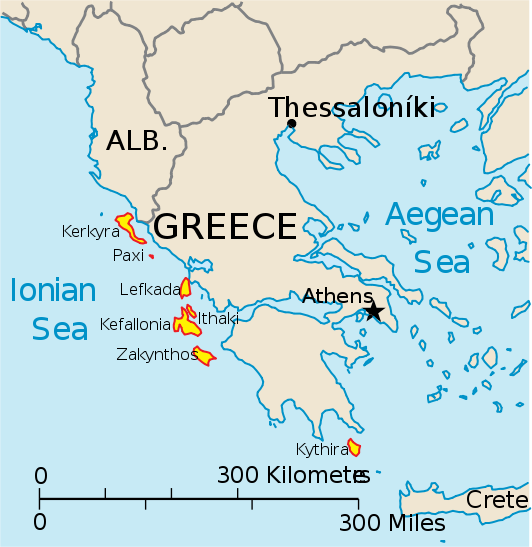
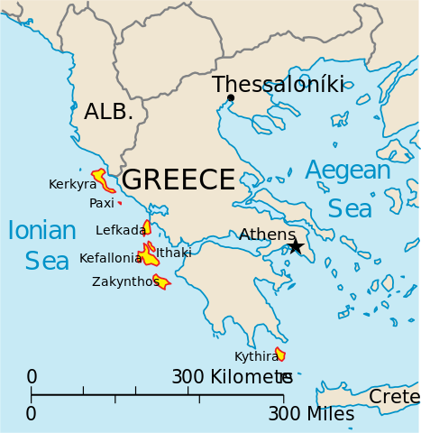
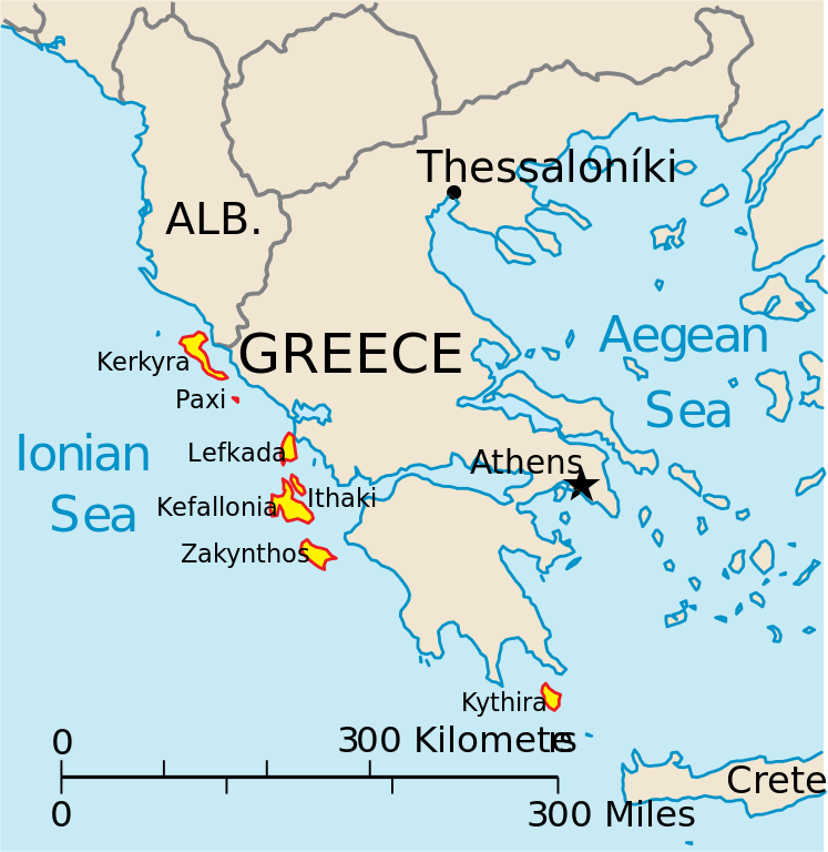
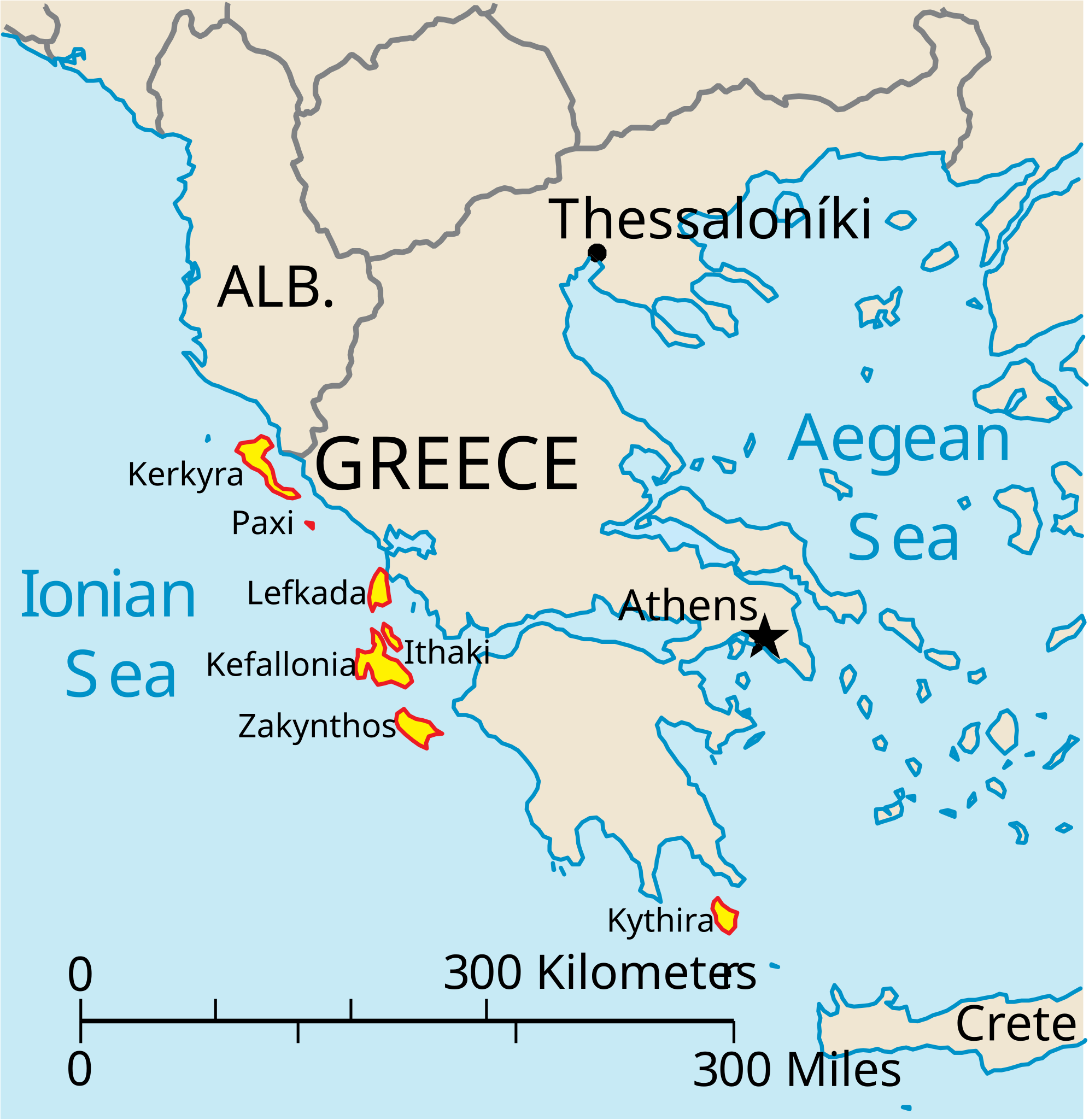
English: Map of the Ionian Islands off Greece. |
| Թուական | |
| Աղբիւր | Սեփական աշխատանք, Original vector data taken from the 2006 CIA World Factbook map of Europe. All modifications were made by me, and are free for anyone to use for any purpose. |
| Հեղինակ | Electionworld |
| Այլ մեկնակերպներ |
Version en français : |
Արտօնագրում
This image is in the public domain because it contains materials that originally came from the United States Central Intelligence Agency's World Factbook.
|
 |
Նիշքի պատմութիւն
Սեղմել օրուան/ժամին վրայ նիշքի այդ պահուն ունեցած վիճակը տեսնելու համար
| Օր/Ժամ | Մանրապատկեր | Ծաւալ | Գործածող | Մեկնաբանութիւն | |
|---|---|---|---|---|---|
| ընթացիկ | 14:39, 4 Ապրիլ 2010 | | 532 × 547 (281 ԿԲ) | Kmusser | rm Macedonia label, not important to the map and avoids POV issue |
| 20:17, 20 Դեկտեմբեր 2006 |  | 532 × 547 (258 ԿԲ) | Electionworld | {{ew|en|IMeowbot}} == Summary == Map of the Ionian Islands off Greece. Original vector data taken from the 2006 CIA World Factbook map of Europe. All modifications were made by me, and are free for anyone to use for any purpose. == Licensing == {{PD-US |
Նիշքի գործածութիւն
Հետեւեալ էջը կը յղուի այս նիշքին՝
Նիշքի համընդհանուր օգտագործում
Հետեւեալ ուիքիները եւս կ'օգտագործեն այս նիշքը՝
- Օգտագործումը ar.wikipedia.org կայքին վրայ
- Օգտագործումը ast.wikipedia.org կայքին վրայ
- Օգտագործումը be.wikipedia.org կայքին վրայ
- Օգտագործումը bg.wikipedia.org կայքին վրայ
- Օգտագործումը ceb.wikipedia.org կայքին վրայ
- Օգտագործումը ce.wikipedia.org կայքին վրայ
- Օգտագործումը cy.wikipedia.org կայքին վրայ
- Օգտագործումը da.wikipedia.org կայքին վրայ
- Օգտագործումը de.wikipedia.org կայքին վրայ
- Օգտագործումը en.wikipedia.org կայքին վրայ
- Օգտագործումը et.wikipedia.org կայքին վրայ
- Օգտագործումը fa.wikipedia.org կայքին վրայ
- Օգտագործումը fi.wikipedia.org կայքին վրայ
- Օգտագործումը fr.wikipedia.org կայքին վրայ
- Օգտագործումը he.wikipedia.org կայքին վրայ
- Օգտագործումը hr.wikipedia.org կայքին վրայ
- Օգտագործումը hu.wikipedia.org կայքին վրայ
- Օգտագործումը id.wikipedia.org կայքին վրայ
- Օգտագործումը it.wikipedia.org կայքին վրայ
Տեսնել այս նիշքի աւելի համընդհանուր օգտագործումը: