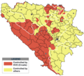
Պատկեր:Hvo controlled.png

Կանխաստուգման չափը՝ 665 × 600 կէտիկ։ Այլ չափեր: 266 × 240 կէտիկ | 532 × 480 կէտիկ | 852 × 768 կէտիկ | 1220 × 1100 կէտիկ.
Սկզբնական նիշք (1220 × 1100 կէտիկներ, նիշքի չափը՝ 99 ԿԲ, MIME-տեսակը՝ image/png)
Նիշքի պատմութիւն
Սեղմել օրուան/ժամին վրայ նիշքի այդ պահուն ունեցած վիճակը տեսնելու համար
| Օր/Ժամ | Մանրապատկեր | Ծաւալ | Գործածող | Մեկնաբանութիւն | |
|---|---|---|---|---|---|
| ընթացիկ | 17:21, 29 Նոյեմբեր 2020 |  | 1220 × 1100 (99 ԿԲ) | Ceha | Tuzla i Bugojno |
| 13:31, 28 Նոյեմբեր 2020 |  | 1220 × 1100 (98 ԿԲ) | Ceha | Dodao neke promjene, od Ravne-Brčko, do Ravnog na jugu (operacija Bura https://hr.wikipedia.org/wiki/Operacija_Bura ) | |
| 17:40, 20 Յուլիս 2011 |  | 1220 × 1100 (48 ԿԲ) | DIREKTOR | Colors | |
| 09:29, 11 Փետրուար 2009 |  | 1220 × 1100 (49 ԿԲ) | Ceha | Corrected errors in Komušina municipality, HVO controled all of Croatian settlments till 10th of August 1991 | |
| 08:24, 11 Օգոստոս 2008 |  | 1220 × 1100 (49 ԿԲ) | Mostarac | {{Information |Description=This is an update for the previous map, as the HVO never controlled all parts of municipality of Mostar and Stolac. Also, HVO never controlled neither part of municipalities Nevesinje, Berkovići and Ljubinje. |Source=self-made | |
| 14:33, 5 Յունուար 2008 |  | 1220 × 1100 (49 ԿԲ) | Nihad Hamzic | Added a legend. Also widened the image slightly to match the size of related images. I did not resize it, but added white space at sides. | |
| 10:08, 17 Յուլիս 2007 |  | 1213 × 1100 (41 ԿԲ) | Nihad Hamzic | Revised the colors to match (to be uniform) with colors in other related maps. | |
| 22:31, 15 Յուլիս 2007 |  | 1213 × 1100 (41 ԿԲ) | Nihad Hamzic | {{Information |Description=BiH territories which were controlled by HVO and regular Croatian Army for some time during the war. <br /> <br /> NOTICE:<br /> This image is a greatly optimised PNG version of the original GIF version of the image. Color dihte |
Նիշքի գործածութիւն
Հետեւեալ էջը կը յղուի այս նիշքին՝
Նիշքի համընդհանուր օգտագործում
Հետեւեալ ուիքիները եւս կ'օգտագործեն այս նիշքը՝
- Օգտագործումը ar.wikipedia.org կայքին վրայ
- Օգտագործումը ast.wikipedia.org կայքին վրայ
- Օգտագործումը bs.wikipedia.org կայքին վրայ
- Օգտագործումը ca.wikipedia.org կայքին վրայ
- Օգտագործումը cs.wikipedia.org կայքին վրայ
- Օգտագործումը de.wikipedia.org կայքին վրայ
- Օգտագործումը es.wikipedia.org կայքին վրայ
- Օգտագործումը eu.wikipedia.org կայքին վրայ
- Օգտագործումը fr.wikipedia.org կայքին վրայ
- Օգտագործումը gl.wikipedia.org կայքին վրայ
- Օգտագործումը hy.wikipedia.org կայքին վրայ
- Օգտագործումը it.wikipedia.org կայքին վրայ
- Օգտագործումը pnb.wikipedia.org կայքին վրայ
- Օգտագործումը pt.wikipedia.org կայքին վրայ
- Օգտագործումը ru.wikipedia.org կայքին վրայ
- Օգտագործումը sr.wikipedia.org կայքին վրայ
- Օգտագործումը sv.wikipedia.org կայքին վրայ
- Օգտագործումը vi.wikipedia.org կայքին վրայ
