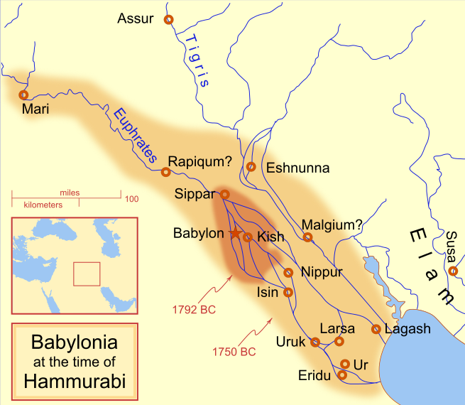
Պատկեր:Hammurabi's Babylonia 1.svg

Size of this PNG preview of this SVG file: 655 × 570 կէտիկ. Այլ չափեր: 276 × 240 կէտիկ | 552 × 480 կէտիկ | 883 × 768 կէտիկ | 1177 × 1024 կէտիկ | 2353 × 2048 կէտիկ.
Սկզբնական նիշք (SVG նիշք, անուանապէս 655 × 570 կէտիկ, նիշքի չափը՝ 183 ԿԲ)
Նիշքի պատմութիւն
Սեղմել օրուան/ժամին վրայ նիշքի այդ պահուն ունեցած վիճակը տեսնելու համար
| Օր/Ժամ | Մանրապատկեր | Ծաւալ | Գործածող | Մեկնաբանութիւն | |
|---|---|---|---|---|---|
| ընթացիկ | 09:14, 21 Ապրիլ 2013 |  | 655 × 570 (183 ԿԲ) | Citypeek | Cleanup of file. Valid SVG now. |
| 19:06, 27 Ապրիլ 2010 |  | 655 × 570 (168 ԿԲ) | DieBuche | removed border | |
| 15:05, 30 Յուլիս 2009 |  | 661 × 580 (317 ԿԲ) | Amit6 | Some nodes changed. | |
| 23:24, 3 Մարտ 2008 |  | 661 × 580 (163 ԿԲ) | MapMaster | Added city-state, moved Sippar, minor other changes based on recent Kassite map | |
| 16:06, 23 Փետրուար 2008 |  | 661 × 580 (161 ԿԲ) | MapMaster | Added 1 city, added name for 1 city | |
| 03:29, 21 Փետրուար 2008 |  | 661 × 580 (159 ԿԲ) | MapMaster | "blurred" the territory outlines | |
| 23:25, 20 Փետրուար 2008 |  | 661 × 580 (155 ԿԲ) | MapMaster | Changes made based on info from ''Mesopotamia and the Bible'' | |
| 02:03, 19 Փետրուար 2008 |  | 663 × 580 (156 ԿԲ) | MapMaster | Fixed an error on my part | |
| 21:12, 18 Փետրուար 2008 |  | 332 × 292 (156 ԿԲ) | MapMaster | some minor edits | |
| 19:19, 18 Փետրուար 2008 |  | 332 × 293 (154 ԿԲ) | MapMaster | removed unrenderable bmp |
Նիշքի գործածութիւն
Հետեւեալ էջը կը յղուի այս նիշքին՝
Նիշքի համընդհանուր օգտագործում
Հետեւեալ ուիքիները եւս կ'օգտագործեն այս նիշքը՝
- Օգտագործումը af.wikipedia.org կայքին վրայ
- Օգտագործումը als.wikipedia.org կայքին վրայ
- Օգտագործումը am.wikipedia.org կայքին վրայ
- Օգտագործումը ar.wikipedia.org կայքին վրայ
- Օգտագործումը arz.wikipedia.org կայքին վրայ
- Օգտագործումը ast.wikipedia.org կայքին վրայ
- Օգտագործումը azb.wikipedia.org կայքին վրայ
- Օգտագործումը az.wikipedia.org կայքին վրայ
- Օգտագործումը ba.wikipedia.org կայքին վրայ
- Օգտագործումը bg.wikipedia.org կայքին վրայ
- Օգտագործումը bjn.wikipedia.org կայքին վրայ
- Օգտագործումը bn.wikipedia.org կայքին վրայ
- Օգտագործումը br.wikipedia.org կայքին վրայ
- Օգտագործումը ceb.wikipedia.org կայքին վրայ
- Օգտագործումը cs.wikipedia.org կայքին վրայ
- Օգտագործումը cy.wikipedia.org կայքին վրայ
- Օգտագործումը da.wikipedia.org կայքին վրայ
- Օգտագործումը de.wikipedia.org կայքին վրայ
- Օգտագործումը diq.wikipedia.org կայքին վրայ
- Օգտագործումը el.wikipedia.org կայքին վրայ
- Օգտագործումը en.wikipedia.org կայքին վրայ
Տեսնել այս նիշքի աւելի համընդհանուր օգտագործումը:


