
Պատկեր:Gedrosia-Map-Route-of-Alexander-1823-Lucas.png

Կանխաստուգման չափը՝ 596 × 600 կէտիկ։ Այլ չափեր: 239 × 240 կէտիկ | 477 × 480 կէտիկ | 656 × 660 կէտիկ.
Սկզբնական նիշք (656 × 660 կէտիկներ, նիշքի չափը՝ 881 ԿԲ, MIME-տեսակը՝ image/png)
Ամփոփում
| Նկարագրութիւն |
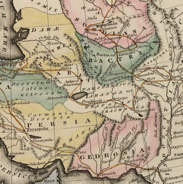
Map of the route of Alexander the Great in South Asia,
|
||||||||||||||||||||
| Թուական | |||||||||||||||||||||
| Աղբիւր | scanned from Plate 12 of A general atlas containing distinct maps of all the known countries in the world by Fielding Lucas | ||||||||||||||||||||
| Հեղինակ |
engraved by J. Yeager; published by
|
||||||||||||||||||||
| Արտօնութիւն (Նիշքի վերօգտագործում) |
Public Domain | ||||||||||||||||||||

Արտօնագրում
|
Այս պատկերում գտնվող երկչափ ստեղծագործությունը հանրության սեփականություն է ամբողջ աշխարհում հեղինակի մահվան ժամանակի, կամ առաջի հրատարակման պատճառով:
Այսպիսով, տվյալ վերարտադրումը նույնպես հանրության սեփականություն է: Դա վերաբերվում է ԱՄՆ-ում, Գերմանիայում և ուրիշ բազմաթիվ պետություններում ստեղծված երկերին:
| ||||
Նիշքի պատմութիւն
Սեղմել օրուան/ժամին վրայ նիշքի այդ պահուն ունեցած վիճակը տեսնելու համար
| Օր/Ժամ | Մանրապատկեր | Ծաւալ | Գործածող | Մեկնաբանութիւն | |
|---|---|---|---|---|---|
| ընթացիկ | 17:51, 29 Նոյեմբեր 2007 | | 656 × 660 (881 ԿԲ) | Bejnar | {{Information |Description=Map of the route of Alexander the Great through Gedrosia, Bactria, and Sogdiana part of a map entitled "Alexandri Magni Itinera" based upon Melish (1815) ''Atlas of Ancient Geography'' |Source= scanned from Plate 12 of ''A gener |
Նիշքի գործածութիւն
Հետեւեալ էջը կը յղուի այս նիշքին՝
Նիշքի համընդհանուր օգտագործում
Հետեւեալ ուիքիները եւս կ'օգտագործեն այս նիշքը՝
- Օգտագործումը bg.wikipedia.org կայքին վրայ
- Օգտագործումը ca.wikipedia.org կայքին վրայ
- Օգտագործումը cs.wikipedia.org կայքին վրայ
- Օգտագործումը de.wikipedia.org կայքին վրայ
- Օգտագործումը en.wikipedia.org կայքին վրայ
- Օգտագործումը eo.wikipedia.org կայքին վրայ
- Օգտագործումը fr.wikipedia.org կայքին վրայ
- Օգտագործումը hr.wikipedia.org կայքին վրայ
- Օգտագործումը id.wikipedia.org կայքին վրայ
- Օգտագործումը it.wikipedia.org կայքին վրայ
- Օգտագործումը ko.wikipedia.org կայքին վրայ
- Օգտագործումը nl.wikipedia.org կայքին վրայ
- Օգտագործումը pl.wikipedia.org կայքին վրայ
- Օգտագործումը pt.wikipedia.org կայքին վրայ
- Օգտագործումը ru.wikipedia.org կայքին վրայ
- Օգտագործումը sh.wikipedia.org կայքին վրայ
- Օգտագործումը tr.wikipedia.org կայքին վրայ
- Օգտագործումը uk.wikipedia.org կայքին վրայ
- Օգտագործումը vi.wikipedia.org կայքին վրայ
- Օգտագործումը www.wikidata.org կայքին վրայ