
Պատկեր:1820 Salem Massachusetts map bySaunders BPL 12094.png

Կանխաստուգման չափը՝ 800 × 541 կէտիկ։ Այլ չափեր: 320 × 216 կէտիկ | 640 × 433 կէտիկ | 1052 × 711 կէտիկ.
Սկզբնական նիշք (1052 × 711 կէտիկներ, նիշքի չափը՝ 1,2 ՄԲ, MIME-տեսակը՝ image/png)
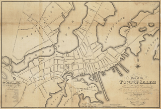
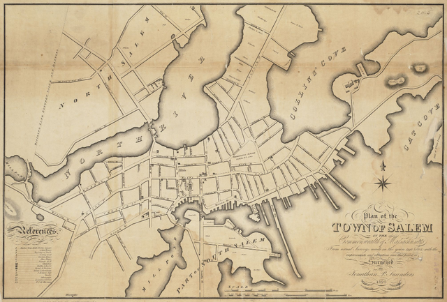
| Նկարագրութիւն | Plan of the town of Salem in the commonwealth of Massachusetts, from actual surveys, made in the years 1796 & 1804; with the improvements and alterations since that period as surveyed |
| Թուական | |
| Աղբիւր | http://maps.bpl.org/details_12094 |
| Հեղինակ | Saunders, Jonathan Peele |
This media file is in the public domain in the United States. This applies to U.S. works where the copyright has expired, often because its first publication occurred prior to January 1, 1929, and if not then due to lack of notice or renewal. See this page for further explanation.
|
 | |
 |
This image might not be in the public domain outside of the United States; this especially applies in the countries and areas that do not apply the rule of the shorter term for US works, such as Canada, Mainland China (not Hong Kong or Macao), Germany, Mexico, and Switzerland. The creator and year of publication are essential information and must be provided. See Wikipedia:Public domain and Wikipedia:Copyrights for more details.
|
Նիշքի պատմութիւն
Սեղմել օրուան/ժամին վրայ նիշքի այդ պահուն ունեցած վիճակը տեսնելու համար
| Օր/Ժամ | Մանրապատկեր | Ծաւալ | Գործածող | Մեկնաբանութիւն | |
|---|---|---|---|---|---|
| ընթացիկ | 15:39, 15 Փետրուար 2011 | | 1052 × 711 (1,2 ՄԲ) | M2545 | {{Information |Description=Plan of the town of Salem in the commonwealth of Massachusetts, from actual surveys, made in the years 1796 & 1804; with the improvements and alterations since that period as surveyed |Source=http://maps.bpl.org/details_12094 |D |
Նիշքի գործածութիւն
Հետեւեալ էջը կը յղուի այս նիշքին՝
Նիշքի համընդհանուր օգտագործում
Հետեւեալ ուիքիները եւս կ'օգտագործեն այս նիշքը՝
- Օգտագործումը be.wikipedia.org կայքին վրայ
- Օգտագործումը de.wikipedia.org կայքին վրայ
- Օգտագործումը en.wikipedia.org կայքին վրայ
- Salem, Massachusetts
- Salem Harbor
- Nathaniel Bowditch House
- Nathaniel Hawthorne Birthplace
- Pickering House (Salem, Massachusetts)
- Crowninshield–Bentley House
- Salem Maritime National Historic Site
- Salem Hospital (Massachusetts)
- Quaker Meeting House (Peabody Essex Museum)
- Cotting–Smith Assembly House
- Andrew–Safford House
- Stephen Phillips House
- Hamilton Hall (Salem, Massachusetts)
- John Ward House (Salem, Massachusetts)
- Gardner–Pingree House
- Bridge Street Neck Historic District
- Charter Street Historic District
- Chestnut Street District
- City Hall (Salem, Massachusetts)
- Crombie Street District
- Derby Waterfront District
- Downtown Salem District
- Gedney and Cox Houses
- West Cogswell House
- Salem Common Historic District (Salem, Massachusetts)
- Phillips Library (Massachusetts)
- Timeline of Salem, Massachusetts
- Joseph Fenno House
- Օգտագործումը es.wikipedia.org կայքին վրայ
- Օգտագործումը fr.wikipedia.org կայքին վրայ
- Օգտագործումը hy.wikipedia.org կայքին վրայ
- Օգտագործումը it.wikipedia.org կայքին վրայ
- Օգտագործումը ja.wikipedia.org կայքին վրայ
- Օգտագործումը kk.wikipedia.org կայքին վրայ
- Օգտագործումը ky.wikipedia.org կայքին վրայ
- Օգտագործումը lmo.wikipedia.org կայքին վրայ
- Օգտագործումը mr.wikipedia.org կայքին վրայ
- Օգտագործումը pl.wikipedia.org կայքին վրայ
- Օգտագործումը pt.wikipedia.org կայքին վրայ
- Օգտագործումը ro.wikipedia.org կայքին վրայ
- Օգտագործումը ru.wikipedia.org կայքին վրայ
- Օգտագործումը sh.wikipedia.org կայքին վրայ
- Օգտագործումը sr.wikipedia.org կայքին վրայ
- Օգտագործումը sv.wikipedia.org կայքին վրայ
- Օգտագործումը tr.wikipedia.org կայքին վրայ
Տեսնել այս նիշքի աւելի համընդհանուր օգտագործումը: