
Պատկեր:Roman Empire with provinces in 210 AD.png

Կանխաստուգման չափը՝ 800 × 551 կէտիկ։ Այլ չափեր: 320 × 221 կէտիկ | 640 × 441 կէտիկ | 1024 × 706 կէտիկ | 1280 × 882 կէտիկ | 2052 × 1414 կէտիկ.
Սկզբնական նիշք (2052 × 1414 կէտիկներ, նիշքի չափը՝ 247 ԿԲ, MIME-տեսակը՝ image/png)
Ամփոփում
| Նկարագրութիւն |
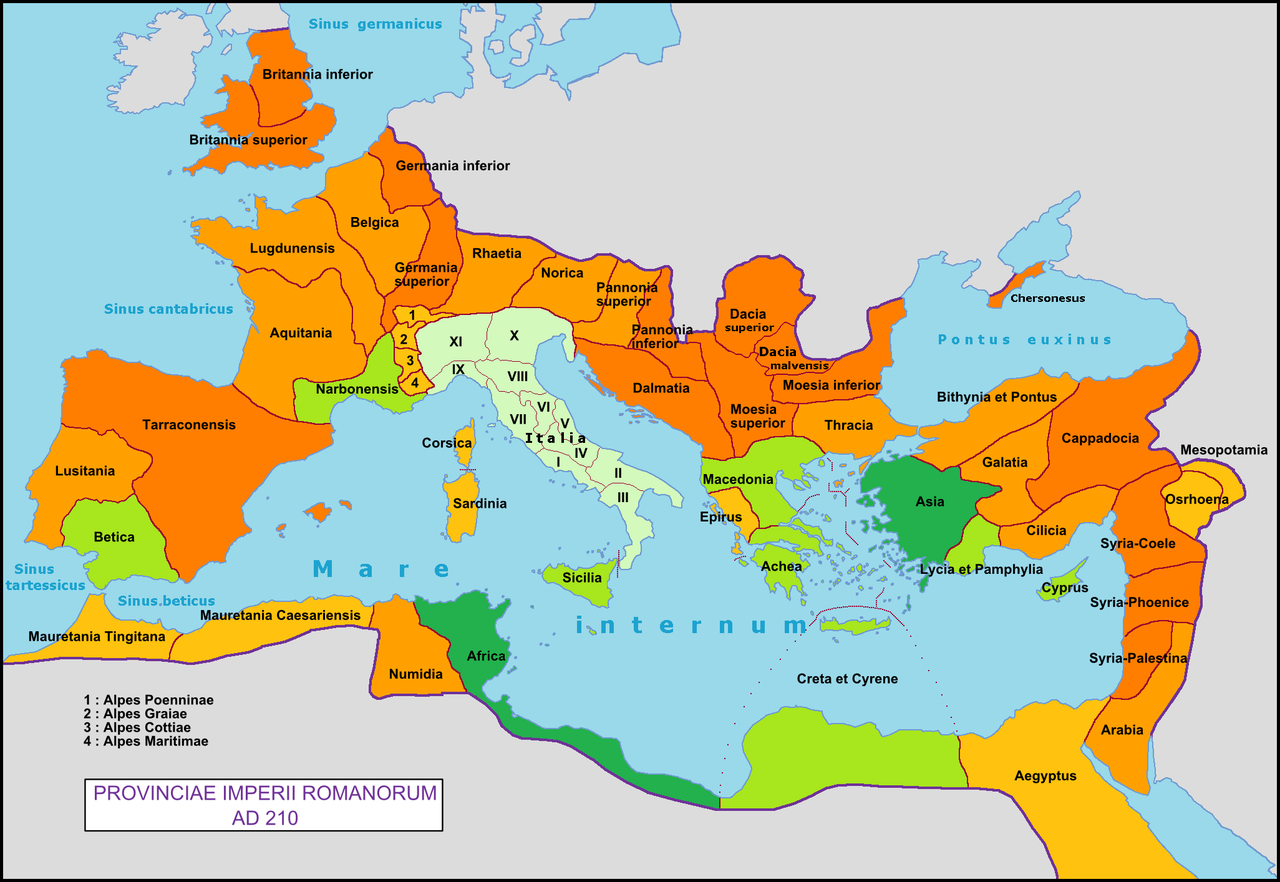
English: Map of the Roman Empire with the provinces of 210 AD.
Français : Carte de l'Empire romain avec ses provinces en 210 ap. J.-C. |
| Թուական | |
| Աղբիւր | Սեփական աշխատանք |
| Հեղինակ | Mandrak |
| Այլ մեկնակերպներ |
|
Արտօնագրում
| I, the copyright holder of this work, release this work into the public domain. This applies worldwide. In some countries this may not be legally possible; if so: I grant anyone the right to use this work for any purpose, without any conditions, unless such conditions are required by law. |
Նիշքի պատմութիւն
Սեղմել օրուան/ժամին վրայ նիշքի այդ պահուն ունեցած վիճակը տեսնելու համար
| Օր/Ժամ | Մանրապատկեր | Ծաւալ | Գործածող | Մեկնաբանութիւն | |
|---|---|---|---|---|---|
| ընթացիկ | 20:18, 15 Փետրուար 2020 | | 2052 × 1414 (247 ԿԲ) | Trecătorul răcit | Italia, Chersonesus, some details |
| 12:49, 10 Մարտ 2009 |  | 2052 × 1414 (260 ԿԲ) | Mandrak | {{Information |Description={{en|1=Map of the Roman Empire with the provinces of 210 AD.}} {{fr|1=Carte de l'Empire romain avec ses provinces en 210 ap. J.-C.}} |Source=travail personnel (own work) |Author=Mandrak |Date= |Permission= |othe |
Նիշքի գործածութիւն
Հետեւեալ էջը կը յղուի այս նիշքին՝
Նիշքի համընդհանուր օգտագործում
Հետեւեալ ուիքիները եւս կ'օգտագործեն այս նիշքը՝
- Օգտագործումը de.wikibooks.org կայքին վրայ
- Օգտագործումը de.wikiversity.org կայքին վրայ
- Օգտագործումը en.wikipedia.org կայքին վրայ
- Օգտագործումը en.wiktionary.org կայքին վրայ
- Օգտագործումը es.wikipedia.org կայքին վրայ
- Օգտագործումը et.wikipedia.org կայքին վրայ
- Օգտագործումը eu.wikipedia.org կայքին վրայ
- Օգտագործումը fi.wikibooks.org կայքին վրայ
- Օգտագործումը fr.wikipedia.org կայքին վրայ
- Օգտագործումը fr.wikiversity.org կայքին վրայ
- Օգտագործումը gl.wikipedia.org կայքին վրայ
- Օգտագործումը hy.wikipedia.org կայքին վրայ
- Օգտագործումը is.wikipedia.org կայքին վրայ
- Օգտագործումը it.wikipedia.org կայքին վրայ
- Օգտագործումը it.wikibooks.org կայքին վրայ
- Օգտագործումը lt.wikipedia.org կայքին վրայ
- Օգտագործումը pl.wikipedia.org կայքին վրայ
- Օգտագործումը sl.wikipedia.org կայքին վրայ
- Օգտագործումը tr.wikipedia.org կայքին վրայ
- Օգտագործումը uk.wikipedia.org կայքին վրայ